Agua Fria National Monument
| Agua Fria National Monument | ||
|---|---|---|
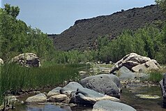
| The river in the canyon | ||
|
|
||
| Location: | Arizona , United States | |
| Specialty: | Table mountains and canyons with prehistoric Indian settlements | |
| Next city: | Camp Verde | |
| Surface: | 287.7 km² | |
| Founding: | January 11, 2000 | |
Agua Fria National Monument is a protected area by the type of National Monuments in the State of Arizona . With two table mountains and the canyon of the Agua Fria River cut in between, it preserves an archaeologically important settlement area of prehistoric Indian peoples of the Anasazi - or Sinagua culture, with over 450 remains of buildings identified to date.
The National Monument was established in early 2000 by US President Bill Clinton and is administered by the Bureau of Land Management , an agency under the umbrella of the US Department of the Interior . The name of the river and the reserve comes from the Spanish and means "cold water".

description
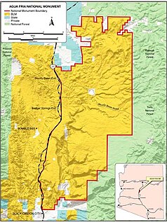
The National Monument is located in Yavapai County in central Arizona. The western limit of the reserve is Interstate Highway I-17 . To the north is the small town of Cordes Lakes and the experimental town of Arcosanti by Paolo Soleri from 1970. In the east is the Tonto National Forest , a national forest under the administration of the US Forest Service . To the south is Black Canyon City .
The area is characterized by the two table mountains Perry Mesa and Black Mesa and the canyon of the Agua Fria River, which runs from north to south in between. The altitude of the reserve ranges from 650 m on the river to 1400 m in the northern hills. The climate is semi-arid , the largely flat plateau above the canyon is overgrown with the plant communities of the semi-desert. The saguaro cactus is most noticeable. There is a gallery forest by the river, dominated by plane trees , poplars and willows .
The wildlife of the monument includes pronghorn , mule deer , white-tailed deer and collar peccary, as well as pumas . In addition, small mammals, diverse bird species, including in particular birds of prey . The river still contains the original fish fauna and a number of amphibian species. The Gila crustacean stands out among the reptiles . Wapitis and black bears sporadically come to the protected area from the neighboring forest .
Between the years 1250 and 1450, the height of the settlement of today's monument by prehistoric Indian peoples was. Several thousand people lived in the canyon and the side canyons. They grew corn , squash, and beans in fields by the river , hunted, and gathered acorns , which they ground into flour. Because the land at the bottom of the canyon was needed for agriculture, they built their houses from adobe adobe bricks and field stones on the slopes. Over 450 settlement sites have been found in the protected area so far, the largest encompassing over 100 rooms and being inhabited by several hundred people. The Anasazi culture collapsed around 1450, due to prolonged drought due to climate change or systematic overuse of the soil.
In the 19th century several ore mines were established in the area , they were not productive for long and were mostly closed after a few years or a few decades. Ranchers used the area as pastureland before it was placed under protection and to this day.
Agua Fria National Monument today
Like almost all National Monuments that have been newly established in recent years, Agua Fria is still under construction. There is no visitor center, no campsites, developed roads or even sources of drinking water. Visitors can use the area for hiking, natural history excursions, and nature photography. Hunting is also permitted within the framework of the statutory provisions. Everyone can camp freely in the area, but only the existing gravel roads are allowed. Off-road, trekking is the only way of getting around.
The city of Phoenix , which is only about 50 km south of the protected area, is the fastest growing metropolis in the United States, the settlement pressure on undeveloped land, the grazing of large areas by cattle herds of private ranchers, which has increased since the designation as a protected area, and the increase in recreational use and Robbery excavations at the archaeological sites strain the area and its protection goals.
Web links
- Bureau of Land Management: Aguai Fria National Monument (official site )
- Aguai Fria National Monument on the website of a coalition of conservation organizations


