Ahlersbach (Kinzig, Schlüchtern-Niederzell)
| Ahlersbach | ||
|
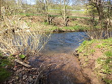
The Ahlersbach near Niederzell |
||
| Data | ||
| Water code | DE : 2478152 | |
| location |
Hessian-Franconian mountainous region
|
|
| River system | Rhine | |
| Drain over | Kinzig → Main → Rhine → North Sea | |
| source | east of Steinau -Bellings 50 ° 18 '18 " N , 9 ° 31' 57" O |
|
| Source height | 385 m above sea level NHN | |
| muzzle | between Schlüchtern - Niederzell and Steinau in the Kinzig coordinates: 50 ° 19 ′ 32 ″ N , 9 ° 29 ′ 22 ″ E 50 ° 19 ′ 32 ″ N , 9 ° 29 ′ 22 ″ E |
|
| Mouth height | 185 m above sea level NHN | |
| Height difference | 200 m | |
| Bottom slope | approx. 43 ‰ | |
| length | approx. 4.6 km | |
| Catchment area | 11.157 km² | |
The Ahlersbach is a four and a half kilometers long left and south tributary of the Kinzig in the Main-Kinzig district in the Hessian Spessart .
geography
course
The Ahlersbach rises at an altitude of 385 m above sea level. NHN almost two kilometers east of the Steinau district of Bellings in a mixed forest at the southeastern foot of the Waizenberg . Its source, known as Schwarzborn , is located in the FFH area Kinzigsystem above Steinau an der Straße , which it will not leave until the mouth.
It flows first in a westerly direction through the Bellingser community forest , then changes to the northwest and runs for about half a kilometer through the southwest area of the NSG Waizenberg near Hohenzell . It is now leaving the nature reserve and, accompanied by wood in the grassland, runs through the Katzental along the western foot of the Waizenberg, directing its course more and more to the west. At the Flur Im Reisgrund, it flows through a small pond and moves about half a kilometer north of the village of Bellings west-northwest through meadows. To the northeast of the 344.8 m above sea level standing in a flora and fauna habitat . NHN high Bellinger Berg , he is strengthened in the Breitwiesen corridor on his left by the Erlenbach coming from the south .

The Ahlersbach now flows just under a kilometer in a strip of grassland bounded by mixed forest northwest, then turns north in the beech corridor , then runs past a small sewage treatment plant and finally flows out at an altitude of 185 m above sea level. NHN between Schlüchtern district Niederzell in the northeast and Steinau in the southwest from the left into the Kinzig .
Its approximately 4.6 km long run ends 200 meters below its source, so it has an average bed gradient of 43 ‰.
Tributaries
- Erlenbach ( left ), 4.2 km
