
Aigai (Aeolis)
Coordinates: 38 ° 50 ' N , 27 ° 11' E


Aigai , also Aigaiai ( Greek Αἰγαί, Αἰγαῖαι ), Latin Aegae , Aegaeae , in Turkish also Nemrutkale or Nemrut Kalesi , is an ancient city in the historical region of Aeolia . It is located on the Gün Dağı ridge near the village of Köseler in the Manisa district of the Turkish province of Manisa , about 35 km south of Pergamon ( Bergama ), 20 km east of Aliağa .
history
Aigai is mentioned by Herodotus and Strabo . In the eighth century BC it belonged to the Aeolian League of Twelve Cities, after which it belonged to the Lydian and later to the Persian Empire . At the beginning of the fourth century BC It was part of the Pergamene Empire. After it was temporarily owned by the Seleucids , it became in 218 BC. Recaptured by Attalus I for Pergamon. In the war between Pergamon and Bithynia it was 156 BC. Destroyed by Prusias II . After a peace brokered by the Romans , the city was compensated with 100 talents . Under the Pergamene rule, markets and a temple of Apollo were built.
In AD 17, after the end of the Attalid dynasty in 133 BC , Aigai became BC under Roman rule, completely destroyed by an earthquake, but received help from Emperor Tiberius for the reconstruction.
ruins

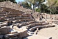
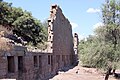
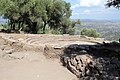
The city lies on the summit plateau of the steep Gün Dağı, which can be climbed from the north. The plateau is surrounded by a wall 1.5 km in length. The remains of the three-story market hall are on the eastern slope. They are preserved up to a height of 11 m and 82 m long. The upper floor of the Hellenistic building was renovated in Roman times. Scattered around the site are the remains of numerous buildings, some of which are overgrown, including the terraced acropolis , a theater, a grammar school , a buleuterion and the foundations of three temples.
About five kilometers to the east (an hour's walk), on the banks of the stream that flows around the Stadtberg, are the foundations of an Apollon sanctuary, an Ionic peripteral temple from the first century BC. BC, of which the six meter high cellator made of three monoliths has survived .
Research history
The first western visitors to Aigai were William Mitchell Ramsay and Salomon Reinach , who reported on it in 1881 in the Journal of Hellenic Studies and in 1882 in the Bulletin de correspondance hellénique . They were followed by the building researcher Richard Bohn and the prehistorian Carl Schuchhardt , who examined the site as part of the excavations in Pergamon and published their work Antiquities of Aegae in 1989.
Since 2004, excavations have been carried out in Aigai under the direction of Ersin Doğer from Ege Üniversitesi in Izmir . So far (2010) the access road, a bouleuterion, an odeon , shops, numerous water pipes and large parts of the market hall have been exposed. In the next few years it is planned to rebuild the facade with the numerous original stones that still exist.

Ascent
Bouleuterion
Facade of the market hall
Meat and fish market in front of the market hall


literature
- Richard Bohn, Carl Schuchardt (ed.): Antiquities from Aegae . Reimer, Berlin 1889 (Yearbook of the Imperial German Archaeological Institute, supplement 2; online )
- George Ewart Bean : Aigai, Aiolis, Turkey . In: Richard Stillwell et al. a. (Ed.): The Princeton Encyclopedia of Classical Sites. Princeton University Press, Princeton NJ 1976, ISBN 0-691-03542-3 .
- Gustav Hirschfeld : Aigai 5 . In: Paulys Realencyclopadie der classischen Antiquity Science (RE). Volume I, 1, Stuttgart 1893, Col. 944 f.
Web links
Individual evidence
- ↑ Herodotus 1, 149 ( English translation ).
- ↑ Strabon 13, 3, 5 ( English translation ; German translation: Christoph Gottlieb Groskurd (transl.): Strabon's description of the earth in seventeen books. Volume 2. Nicolai, Berlin and Stettin 1831, p. 614, on GoogleBooks ).
- ↑ Polybios 5, 77, 4.
- ↑ Polybios 33, 13 ( English translation ).
- ↑ Tacitus , Annales 2, 47 ( English translation )
- ↑ a b Marianne Mehling (Ed.): Knaurs Culture Guide in Color Turkey . Droemer-Knaur, 1987, ISBN 3-426-26293-2 , p. 451.
- ↑ a b Gernot Lang: Classical Ancient Sites Anatolia , Books on Demand 2003, ISBN 3-8330-0068-6 , p. 37 ( on GoogleBooks ).