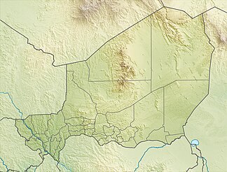
Aïr
| Aïr | ||
|---|---|---|
|
Image taken from space by Gemini 6 |
||
| Highest peak | Idoukal-n-Taghès ( 2022 m ) | |
| location | Niger | |
|
|
||
| Coordinates | 18 ° 32 ' N , 8 ° 37' E | |
The Aïr [ aˈiːr ] ( Hausa : Abzin ) is a high mountain range in central Niger (Africa). It consists of a chain of mountains that rise up to 1500 meters in a north-south direction from the eastern sandy desert of Ténéré . The highest mountain at 2022 m is Idoukal-n-Taghès (also called Mont Bagzane ) in the southern part . The north-easterly wind blows the sand up to 400 m high dunes in the shadow of the mountains . Especially on the west side, numerous wadis rugged the mountains.
It has some oases with sedentary Tuaregs , mainly Kel Ewey , who live from gardening and pasture farming. The groundwater required for this is pumped from a well. Rain farming, however, is not possible. The pastoral economy focuses on camels and goats because they are tree-grazing. The most famous oases are Timia , a mountain oasis, Iferouane and Tabelot . The economy of the Kel Ewey-Tuareg is characterized by the triangular trade between the Aïr, Bilma and Kano in Nigeria . The Arlit uranium mines are located on the western foothills .
The northern part of the Aïr Mountains is part along with the northeastern section of the desert Ténéré since 1991 for World Natural Heritage of UNESCO . The Aïr and Ténéré nature reserve is the largest protected area in Africa with 77,000 km².
The mountain region forms a Sahel enclave in the middle of the Sahara and the northernmost point where vegetation can be found to a greater extent after crossing the desert. Predominant trees are toothbrush and Ana trees , caper plants ( Maerua Crassifolia ) Wüstendatteln , doum palms , Boscia senegalensis-bushes, Acaciae and Osher . They thrive on the edges of river valleys, which occasionally carry water if it has rained on the upper reaches. Even Mediterranean plants can survive in the higher elevations. Due to its remote location, there are also wild forms of a number of important cultivated plants, such as wild olives , pearl millet and sorghum . The animal world is diverse with 40 mammals, 165 bird and 18 reptile species. At the end of the 1980s, five endangered species were observed: Dama and Dorkas gazelle , barbary sheep , mendes antelope and African ostrich . Hunting is a massive threat to their population. After the number of Mendes antelopes had temporarily decreased to 15 animals, over a hundred animals were finally observed again. When breeding animals were released into the wild, ostriches had to be reintroduced.
Since the Tuareg uprisings in 1992, the area has been on the Red List of World Heritage in Danger . The various political upheavals in Niger and the impression of the World Heritage Committee that the government is doing too little against poaching and to preserve the protected area have so far prevented it from being removed from the list.
In the south of the mountains lies the Gadoufaoua excavation area , which is important for paleo-archeology , the so-called dinosaur cemetery of the Sahara.
The Aïr is the setting of the 1927 adventure novel Au pays de la peur by Étienne de Riche .
literature
- Gerd Spittler : Droughts, war and hunger crises among the Kel Ewey (1900–1985). Stuttgart: Franz Steiner, 1989 (monograph).
Individual evidence
- ↑ Edmond Séré de Rivières: Histoire du Niger . Berger-Levrault, Paris 1965, p. 62.
- ↑ a b c Gerd Spittler , Dürren, Krieg und Hungerkrisen, p. 1 ff. (See lit.)
- ↑ Resolution 29 COM 7A.6 of the World Heritage Committee, 2005
- ^ Daniel Mignot, Jean-Dominique Pénel: Le Niger dans la littérature française . In: Marie-Clotilde Jacquey (ed.): Littérature nigérienne (= Notre librairie . No. 107 ). CLEF, Paris 1991, p. 26 .
Web links
- Entry on the UNESCO World Heritage Center website ( English and French ).
- Data sheet of the UNEP-WCMC ( Memento of November 3, 2008 in the Internet Archive ) (English)
- Treasures of the World - Heritage of Humanity ( Memento from September 6, 2009 in the Internet Archive )


