Alberche
|
Alberche Río Alberche |
||
| Data | ||
| location | Spain | |
| River system | Tagus | |
| Drain over | Tagus → Atlantic | |
| source | In the Sierra de Gredos 40 ° 23 ′ 30 ″ N , 5 ° 16 ′ 48 ″ W. |
|
| Source height | approx. 1800 msnm | |
| muzzle | Above Talavera de la Reina in the Tajo Coordinates: 39 ° 57 ′ 49 ″ N , 4 ° 46 ′ 17 ″ W 39 ° 57 ′ 49 ″ N , 4 ° 46 ′ 17 ″ W. |
|
| Mouth height | approx. 375 msnm | |
| Height difference | approx. 1425 m | |
| Bottom slope | approx. 7.8 ‰ | |
| length | 182 km | |
| Left tributaries | Río Cofio, Río Perales | |
| Medium-sized cities | Navaluenga , El Tiemblo , San Martín de Valdeiglesias | |
|
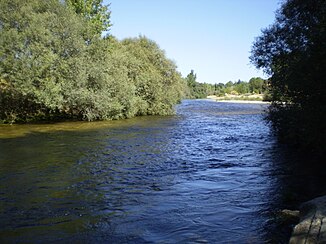
At Aldea del Fresno. |
||
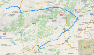
The Alberche is a right tributary of the Tagus with a length of 182 km. It rises at 1800 msnm height approx. 6 km above the village of San Martín de la Vega del Alberche in the province of Ávila in the Sierra de Gredos , the central section of the Castilian divide mountains .
First of all, following a longitudinal valley of the mountains, it mostly flows almost to the east. It is dammed by the dams of the Embalse de Burguillo , Embalse del Charco del Cura and Embalse de San Juan .
At Aldea del Fresno , in the province of the autonomous community of Madrid , it leaves the mountains, turns to the southwest and now runs parallel to the foot of an eastern foothill of the Sierra de Gredos (Sierra de la Higuer, Sierra de San Vicente). There, on its lower reaches, it meanders through a landscape characterized by extensive meadows, also popularly known as Playa de Madrid .
Above Talavera de la Reina , in the province of Toledo , the Alberche finally flows into the Tajo.

