Alberta, Minnesota
| Alberta | |
|---|---|
|
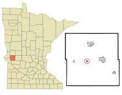
Location in Minnesota
|
|
| Basic data | |
| State : | United States |
| State : | Minnesota |
| County : | Stevens County |
| Coordinates : | 45 ° 34 ′ N , 96 ° 3 ′ W |
| Time zone : | Central ( UTC − 6 / −5 ) |
| Residents : | 103 (as of 2010) |
| Population density : | 147.1 inhabitants per km 2 |
| Area : | 0.7 km 2 (approx. 0 mi 2 ) |
| Height : | 339 m |
| Postal code : | 56207 |
| Area code : | +1 320 |
| FIPS : | 27-00676 |
| GNIS ID : | 639249 |
 The Alberta Teachers House , listed on the NRHP since 1983 |
|
Alberta is a small town (with the status " City ") in Stevens County in the US -amerikanischen State Minnesota . In 2010 Alberta had 103 residents.
geography
Alberta is located in western Minnesota not far from the borders of North Dakota and South Dakota . The geographical coordinates of Alberta are 45 ° 34'24 "north latitude and 96 ° 02'51" west longitude. The urban area extends over an area of 0.7 km².
Neighboring towns in Alberta are Donnelly (9.9 miles north), Morris (7.5 miles east), and Chokio (6.6 miles west).
The closest major cities are Fargo , North Dakota (174 km northwest), Duluth on Lake Superior (393 km northeast), Minneapolis (255 km east-southeast), Minnesota's capital Saint Paul (271 km in the same direction) and Sioux Falls , South Dakota (273 km south-southwest).
traffic
The Minnesota State Route 28 extends in the east-west direction along the southern Ortsrandes. All other roads are subordinate country roads, some unpaved roads and inner-city connecting roads.
A branch line of the BNSF Railway runs in the west-east direction . The company is only active in rail freight transport .
The Morris Municipal Airport is 4 miles west of Alberta, a small airfield. The nearest major airport is Minneapolis-Saint Paul International Airport (270 km east-southeast).
Demographic data
As of the 2010 census , Alberta had 103 people in 41 households. The population density was 147.1 people per square kilometer. Statistically, 2.51 people lived in each of the 41 households.
Ethnically, the population is made up entirely of whites.
22.3 percent of the population were under 18 years old, 62.2 percent were between 18 and 64 and 15.5 percent were 65 years or older. 46.6 percent of the population was female.
The average annual income for a household was 43,250 USD . The per capita income was $ 23,720. 8.8 percent of the population lived below the poverty line.
Individual evidence
- ↑ Extract from the National Register of Historic Places - No. 83000942 Retrieved June 24, 2013
- ↑ a b American Fact Finder. Retrieved June 24, 2013
- ↑ Distance information according to Google Maps. Accessed June 24, 2013
- ↑ AirNav.com - KMOX Retrieved on June 24, 2013
