Alma (Buffalo County)
| Alma | ||
|---|---|---|
![The old town of Alma, listed as a Historic District in the NRHP since 1982 [1]](https://upload.wikimedia.org/wikipedia/commons/thumb/1/13/AlmaWI_HistoricBusinessDistrict.jpg/298px-AlmaWI_HistoricBusinessDistrict.jpg) The old town of Alma, as a Historic District since 1982 NRHP listed |
||
| Location in Wisconsin | ||
|
|
||
| Basic data | ||
| Foundation : | 1856 | |
| State : | United States | |
| State : | Wisconsin | |
| County : | Buffalo County | |
| Coordinates : | 44 ° 20 ′ N , 91 ° 55 ′ W | |
| Time zone : | Central ( UTC − 6 / −5 ) | |
| Residents : | 781 (as of 2010) | |
| Population density : | 51.4 inhabitants per km 2 | |
| Area : | 20.2 km 2 (approx. 8 mi 2 ) of which 15.2 km 2 (approx. 6 mi 2 ) is land |
|
| Height : | 205 m | |
| Postal code : | 54610 | |
| Area code : | +1 608 | |
| FIPS : | 55-01225 | |
| GNIS ID : | 1560795 | |
| Website : | www.almawisconsin.com | |
| Mayor : | Bob Scow | |
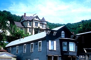
 Typical European style houses in Alma |
||
Alma is a small town (with the status " City ") and the administrative seat of Buffalo County in the US -amerikanischen State Wisconsin . In 2010 , Alma had 781 residents.
geography
Alma is located in western Wisconsin, at the confluence of the Buffalo River with the Mississippi , which forms the border with Minnesota . The geographical coordinates of Alma are 44 ° 20 'north latitude and 91 ° 55' west longitude. The urban area extends over an area of 20.2 km², which is spread over 15.2 km² of land and 5.0 km² of water.
Between Alma and the opposite bank of Minnesota, Lock and Dam No. 4 One of 28 barrages and locks that allow navigation on the Upper Mississippi.
Wisconsin Highway 35 runs through Alma from the north . In the center of the village is the western end point of Wisconsin Highway 37 .
The nearest larger cities are Rochester in Minnesota (approx. 60 km southwest), Eau Claire (approx. 60 km northeast), La Crosse (approx. 75 km southeast) and the Twin Cities ( Minneapolis and Saint Paul ) in Minnesota (approx. 120 km northwest).
population
According to the 2010 census , Alma had 781 people in 386 households. The population density was 51.4 inhabitants per square kilometer. Statistically, 1.95 people lived in each of the 386 households.
The racial the population was composed of 98.5 percent white, 0.1 percent (one person) African American, 0.4 percent Native American and 0.1 percent Asian; 0.9 percent were descended from two or more races. Hispanic or Latino of any race was 0.6 percent of the population.
15.4 percent of the population were under 18 years old, 57.1 percent were between 18 and 64 and 27.5 percent were 65 years or older. 49.0 percent of the population was female.
The average annual income for a household was 37,841 USD . The per capita income was $ 25,564. 9.9 percent of the population lived below the poverty line.
Known residents
- Arnold Gesell (1880–1961), psychologist, pediatrician and co-founder of developmental psychology - born and raised in Alma
Economy and culture
Alma is one of Wisconsin's historic towns along the Great River Road , a collection of US Highways , State Highway and County Roads that connected through ten US -American states and two Canadian provinces on both banks of the Mississippi skirts. The part leading through Alma is designated as the National Scenic Byway , a road that is characterized in its course by sights with an outstanding archaeological, cultural or historical significance, by an environment with a high recreational and leisure value or by natural and landscape features that are particularly worth seeing .
Alma's “Main Street” is listed in the National Register of Historic Places due to its buildings built into the cliffs by the river in the European style of the 19th century (remnants of the first settlers of Swiss origin) .
Above the barrage there is a main nesting site for the bald eagle .
Individual evidence
- ↑ Extract from the National Register of Historic Places - No. 82000631.Retrieved September 2, 2013
- ↑ a b American Fact Finder. Retrieved September 2, 2013

