
Alpspitz (Allgäu Alps)
| Alpspitz | ||
|---|---|---|
 Alpspitz from Edelsberg ( 1630 m ) |
||
| height | 1575 m above sea level NHN | |
| location | Bavaria , Germany | |
| Mountains | Pre-Alps east of the Iller , Allgäu Alps | |
| Dominance | 0.6 km → Edelsberg | |
| Notch height | 55 m | |
| Coordinates | 47 ° 35 '52 " N , 10 ° 29' 49" E | |
|
||
| rock | Flysch | |

The Alpspitz is a 1575 meter high mountain peak in the Bavarian part of the Allgäu Alps .
Location and surroundings
The Alpspitz is located on the northeastern edge of the Allgäu Alps, right on the edge of the Alps . Important valley locations on the Alpspitz are Nesselwang in the north , on whose boundary it is located, as well as Pfronten in the east and Jungholz in the southwest.
The notch height of the Alpspitz is at least 55 meters, its dominance 600 meters, with the Edelsberg ( 1630 m ) in the south being the reference mountain. The independent Reuterwanne ( 1541 m ) is located two kilometers to the west .
Routes to the summit
The summit is easy to reach via forest roads and hiking trails. The quickest and shortest access is from the north via the Alpspitzbahn Nesselwang mountain station on a saddle 75 m below the summit . Other routes lead, for example, via the ruins of Burg Nesselburg or via the pilgrimage church of Maria Trost . There is a wooden cross on the summit.
photos
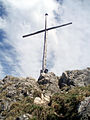
Summit cross

Alpspitz (left) and Edelsberg


Individual evidence
- ↑ a b Dieter Seibert: Alpine Club Guide alpine - Allgäu Alps and Ammergau Alps . 17th edition. Bergverlag Rother, Munich 2008, ISBN 978-3-7633-1126-2 , p. 230 f.
- ↑ Exact value not known, stated value is a minimum value (can be up to 19 meters higher). It was determined from the distance between the contour lines (20 meters in altitude ) on a topographic map ( scale 1: 25,000).
- ↑ Bavarian Surveying Administration : BayernAtlas . Retrieved February 27, 2013.