
Old canal bridge Minden
Coordinates: 52 ° 18 ′ 11 ″ N , 8 ° 55 ′ 54 ″ E
| Old canal bridge Minden | ||
|---|---|---|
 |
||
| Convicted | Mittelland Canal | |
| Crossing of | Weser | |
| place | Minden | |
| overall length | 370 meters | |
| Number of openings | 8 sheets | |
| Load capacity | 24,000 tons | |
| start of building | August 1911 | |
| completion | May 25, 1914 | |
| opening | May 25, 1914 | |
| construction time | 33 months | |
| location | ||
|
||

The old canal bridge Minden on waterway intersection Minden the East Westphalian town of Minden in North Rhine-Westphalia leads the Mittellandkanal over the Weser . It is one of the few cases in which one federal waterway bridges another. Since 1998, a wider, additional new bridge built immediately north of the old canal bridge has been in operation.
location

The old Minden canal bridge spans the Weser valley near the city of Minden and belongs to the Minden waterway intersection. To the south and north of the Mittelland Canal and thus on the eastern and western banks of the Weser, a lock system can be used to ascend and descend from the Mittelland Canal, which is 13.3 meters higher, into the Weser and vice versa.
While the Mittelland Canal enables the east-west voyage from the Rhine to Berlin and further to Eastern Europe , ships on the dammed Mittelweser can reach the northern German ports of Bremen and Bremerhaven as well as the Port of Hamburg via the Elbe Lateral Canal . The expansion to large motor cargo ships will create a hinterland port for sea traffic , which, with the RegioPort OWL container port and the container port in the industrial port, will allow a trimodal hub and scheduled liner service .
The old canal bridge is located on the Mittelland Canal and is part of the north German lowlands . The Mittelland Canal uses this level north of the German low mountain range for a shipping route with small differences in altitude. The old canal bridge is 49 meters above sea level north of the city of Minden, industrial areas and the ports of Minden are to the east and west of the old canal bridge on the canal.
history
Construction of the canal bridge began in August 1911 after the Prussian ministerial official Leo Sympher had determined the alignment of the Mittelland Canal. After a 33-month construction period under the direction of engineers Heinrich Küster and Gereke, it was filled with water for the first time on May 25, 1914. At the same time, the main pumping station , the shaft lock with the connecting canal north to the Weser as well as the descent port and the upper lock with the connecting canal south to the Weser and the port basin I of the industrial port were built at the Minden waterway intersection .
During the Second World War the old canal bridge with the waterway cross was the target of air raids. Therefore, the bridge was protected with blocking balloons to prevent air raids. The canal bridge itself was not hit during the attack on October 26, 1944, but the dam of the Mittelland Canal east of the bridge was hit . The water ran out between the lock gates in Hahlen and Beerenbusch and poured into the lower terrain. Some barges were carried away, one of which was used as a barge for a while. 73 workers drowned in the low-lying shelter of the Busch brothers ' crate factory .
In the final phase of the war, on April 4, 1945, the waterless bridge was blown up by the German troops retreating to the eastern bank. As a result, the two river arches collapsed into the Weser and the main pillar was damaged. The canal was already waterless due to the destroyed dam east of the old canal bridge, so there was no flooding. The Weser was dammed by the rubble lying in the water and flowed through the tide arches. In order to channel this water pressure and to enable emergency passage for the Weserschifffahrt, a flood channel was dug through the flood arches in front of the west. This made it possible to restore shipping traffic on the Weser. After the bridge's break had been sealed, shipping was resumed on the Mittelland Canal using the north and south descent.
The reconstruction of the destroyed bridge began in the spring of 1947, using reinforced concrete. On February 18, 1949, the repaired canal bridge over the Weser was opened to traffic again. Remnants of the flood canal were used as a marina for decades .
The bridge has been on the list of monuments of the city of Minden since 1987 and is therefore classified as an architectural monument .
technology

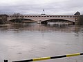
The old canal bridge is 370 meters long. It was created as a trough bridge in a massive construction in reinforced concrete and, in accordance with the architecture of the time, provided with a facing made of sandstone blocks in historicizing shapes. The bridge crosses the valley cut in a total of eight arches. The arches are designed as three-hinged arches and thus carry the construction and water loads.
The actual water trough is sealed with asphalt cardboard, which is protected from anchors, etc. with a two millimeter thick lead membrane. Above this is a 10 centimeter thick layer of clay, which in turn is protected by 10 centimeter thick reinforced concrete slabs. The side walls of the trough are provided with a protective wall made of wood to protect against collisions. When filled with water, the bridge weighs around 24,000 tons. The bridge trough of the old bridge has a water level of 24 meters and a water depth of 3 meters.
To the side of the trough runs a service road on the side sections of the bridge. It is about 2.70 meters wide and can be used on foot at your own risk; crossing on a bicycle is not permitted. To view the trough, there is another official route in the side part of the bridge, which receives light through openings in the wall. It was open to the public for a long time, but is now closed to the public. There are also several maintenance corridors under the trough; they are used to control the joints.
The canal bridge spans the Weser with two arches. The boat trip on the Weser uses the eastern of two arches, the other is hardly flushed with normal water level of water. Six further arches are available for the flood discharge, so that no water stagnation can occur even in extreme floods . The six flood openings have a span of 32 meters each and the two stream openings have a span of 50 meters each. At the highest navigable water level (HSW), the bridge has a passage height of 4.50 meters and a usable width of 30 meters. The bridge structure is clad with basalt lava in the area of the pier base, while the pier heads, the arches, the service parapets and the stair towers are clad with reddish sandstone slabs from the Rhine Palatinate.
The bridge bearings on the bank are flanked by square towers, each with a staircase.
tourism
The Minden waterway intersection and the old canal bridge were the only structures of this type for a long time; It was not until the 1990s that the Magdeburg waterway intersection was restored after being destroyed in the war. Therefore, the old canal bridge and the waterway cross were accompanied by a tourism concept. From the 1950s, there was also a restaurant and a car park on the eastern bank of the shaft lock. The old canal bridge could be hiked from here. In addition, the harbor concerts popular in the 1970s took place in the restaurant. From here it was also possible to access the Minden White Fleet, which regularly organized tourist trips over the waterway intersection.
After the construction of the Weserschleuse Minden , these tourist attractions were relocated to the west side of the exhibition hall of the former Minden Waterways and Shipping Office.
gallery

Old trip, you can see the (newer) flow arcs, as well as the (older) arcs that serve the flood discharge. The auxiliary pumping station can be seen in the background.

Trough the old and new ride side by side from the viewing platform

Old and new ride from below

Empty old trip for maintenance, a drain valve to the Weser can be seen in the right area to empty the bridge for maintenance purposes.
Ship passage from the south, the new voyage can also be seen in the background.


Web links
- Canal bridges on wsa-mittellandkanal-elbe-seitenkanal.wsv.de
- WSA examines canal bridge in Minden on radiowestfalica.de
- Wasserstraßenkreuz Minden aufamtage.de
- Wasserstraßenkreuz Minden on rottenplaces.de
- Minden pumping station, Minden canal bridge on deutsche-digitale-bibliothek.de
- Wasserstraßenkreuz Minden on baukunst-nrw.de
- Information center at the Minden waterway crossing at lwl.org
- Mittelland Canal Bridges Minden with technical data on karl-gotsch.de
Individual evidence
- ↑ a b c Baukunst NRW: The Minden waterway intersection , accessed on March 30, 2016.
- ↑ Buchholz: Development and importance of the Minden waterway intersection, IN BAW Mitteilungen No. 104/2018. In: zw.baw.de. Retrieved October 18, 2020 .
- ↑ 75 years ago bombs fell on the Mittelland Canal. In: mt.de. Retrieved October 18, 2020 .
- ↑ a b c Amtage: Das Wasserstraßenkreuz Minden ( Memento from March 24, 2016 in the Internet Archive ) accessed on March 30, 2016
- ↑ a b WSA Mittellandkanal-ESK: Canal bridges: Minden area of responsibility, accessed on October 18, 2020
- ^ City of Minden: Monument protection: the canal bridges. In: minden.de. Retrieved October 18, 2020 .
- ↑ The XXL TÜV: Stanislaw Kryn puts the canal bridge in Minden through its paces. In: mt.de. Retrieved October 18, 2020 .