Altlayer Bach
| Altlayer Bach | ||
|
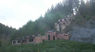
Ruins of the ores of the Adolph-Helene mine in the Altlayer Bachtal |
||
| Data | ||
| Water code | DE : 26796 | |
| location |
Hunsrück
|
|
| River system | Rhine | |
| Drain over | Moselle → Rhine → North Sea | |
| source | at Rödelhausen 49 ° 59 ′ 28 ″ N , 7 ° 19 ′ 43 ″ E |
|
| Source height | approx. 300 m | |
| muzzle | in Zell in the Moselle Coordinates: 50 ° 0 ′ 59 " N , 7 ° 10 ′ 45" E 50 ° 0 ′ 59 " N , 7 ° 10 ′ 45" E
|
|
| length | 11.7 km | |
| Catchment area | 61.604 km² | |
|
When the tide is low, the water runs through the slate spoil |
||
The Altlayer Bach is one of the typical small rivers that flow from the Hunsrück to the Moselle . It rises at approx. 300 m above sea level as Belger Bach near Rödelhausen and flows after 12 km as a right side brook in the local area of Zell .
geography
course
In the upper reaches between Rödelhausen and Altlay it flows through a narrow valley without road connections. There are numerous abandoned slate pits and several mills that are still inhabited. The creek runs partially canalised and underground through the spoil heaps. From Altlay a road accompanies the stream to the mouth. The Altlayer Bach, together with the Hitzelbach, frames the Altlayer Switzerland .
Tributaries
- Belgerbach ( left )
- Hitzelbach ( left )
- Peterswalderbach ( right )
- Linischbach ( right )
Flora and fauna
In the narrow upper reaches, slopes wooded with oak and hornbeam border directly on the stream. At the lower reaches mainly willows and alders , which are hardly used economically today.
Gray herons and mallards are the most common water birds in the Bachtal.
Mining
In the Altlayer Bachtal, iron ore, lead and zinc were mined. At the boundary between Altlay, Belg and Peterswald -akenbofelscheid there are still ruins of the Adolph-Helene mine . The mine, first mentioned in 1409, was finally closed in the 1950s. Overhead management and administration of the mine Adolph-Helene had taken over the mining engineering office from Oskar Daub, engineer mining administrator in Altlay.
Since 1984 slate has been mined underground again in the Altlayer Bachtal. It is currently being mined at a depth of 120 m under the Altlay and Belg districts .
See also
Individual evidence
- ↑ a b GeoExplorer of the Rhineland-Palatinate Water Management Authority ( information )

