Alwar
| Alwar अलवर |
||
|---|---|---|
|
|
||
| State : |
|
|
| State : | Rajasthan | |
| District : | Alwar | |
| Sub-district : | Alwar | |
| Location : | 27 ° 34 ′ N , 76 ° 37 ′ E | |
| Height : | 276 m | |
| Area : | 48.4 km² | |
| Residents : | 322,568 (2011) | |
| Population density : | 6665 inhabitants / km² | |
| Website : | Alwar | |
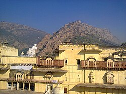
| Alwar - city palace and mountain fortress ( fort ) | ||
Alwar ( Hindi अलवर ) is a city (Municipal Council) with approx. 330,000 inhabitants in the Indian state of Rajasthan .
Location and climate
Alwar is a good 160 km (driving distance) northeast of Jaipur on the eastern edge of the Aravalli Mountains at an altitude of approx. 275 m ; the Indian capital Delhi is approx. 160 km to the northeast. The climate is warm to hot; Rain actually only falls in the summer monsoon months. The highest temperature ever recorded in India was 50.6 ° C and was measured on May 10, 1956 in Alwar.
population
| year | 1991 | 2001 | 2011 |
| Residents | 205.086 | 266.203 | 322,568 |
Almost 90.5% of the population are Hindus , just under 4.5% are Muslims , a good 2.5% are Sikhs and around 2% are Jains ; Members of other religions such as Christians , Buddhists etc. hardly play a role. As is common in northern India, the male population is around 12% higher than the female.
economy
In the area around Alwar, agriculture is practiced before, during and after the monsoon season; Craftsmen, traders and service providers of all kinds have settled in the city itself. Tourism hardly plays a role.
history
The history of the city goes back to the 10th century; at that time the region in the east of Rajasthan was ruled by the princes of Amber / Jaipur. Changing rulers led to a political and military weakening and so the area came under the sovereignty of the Sultanate of Delhi, founded in 1206, and then the Mughal Empire . During and after its decay in the 18th century came the Marathas and also the Jats ; from 1775 Alwar was the capital of a princely state whose political independence was also accepted by the British and which lasted until the country became independent. In 1956 the princely state was dissolved.
Attractions
- The fort of Alwar ( Bala Quila ) , built around the middle of the 16th century and equipped with 6 gates, dominates the city. The Mughal prince Salim (later Jahangir ) spent a number of years in exile here around 1600. Later it passed temporarily into the hands of the Marathas and the Jats.
- The city palace, which was only completed around 1940, now houses a museum. The cenotaph of Maharaja Bakhtawar Singh, also placed here, was built around 1815; since his widow was also burned as sati , the building is also known as Rani Mausi ki Chhatri . It is a fine example of late Mogul architecture refined ; the walls and the roof , designed in the Bengali style, are clad with red sandstone and white marble . In the corners of the building there are chhatris while the middle of the sides is raised by a chaparakat . In the immediate vicinity there is a square stepwell ( baoli ).
- Surroundings
- In the near and far surroundings of Alwar there are several palaces from the 19th and early 20th centuries ( Sariska-Palace , Vijay Mandir palace , Siliserh Lake Palace )


