Amering massif
| Amering massif | ||
|---|---|---|
|
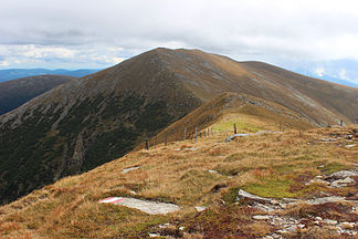
from the Großenberg (Großering) southwards: Ameringkogel , in the back right Weißenstein, left Speikkogel ; fern Koralpe |
||
| Highest peak | Ameringkogel ( 2187 m above sea level ) | |
| location | Styria , Austria | |
| part of | Lavanttal Alps / Styrian Edge Mountains | |
|
|
||
| Coordinates | 47 ° 4 ' N , 14 ° 48' E | |
| particularities | also: Packalpe (in the narrower sense) | |
The Ameringmassiv (also Ameringstock ) is a mountain floor in Styria and small part of Carinthia ( Austria ) and is one of the Lavantal Alps or the Styrian Edge Mountains . The highest peak is the Ameringkogel ( 2187 m above sea level ).
Location and landscape
The Amering massif is the north-western part of the middle section of the Lavanttal Alps known as the Pack and Stubalpe . It extends south of the Aichfeld in the Murtal near Weißkirchen in Styria and along Granitzenbach - Obdacher Sattel and the uppermost Lavanttal , where the Seetal Alps border. In the east, Feistritzbach - Kothbach and Hirschegger Sattel form the border with the Stubalpe . In the south, the Roßbach - Sattelbach - Peterer Sattel - Teigisch line forms the border with the southern part of the Packalpe, which is also known as the Hirschegger Alpe . The stock forms the core area of the Pack / Stubalpe group and is also seen as Packalpe in the narrower sense, the name Amering massif can be found in geological literature. Otherwise it was also seen as the western part of the Stubalpe .
The main ridge of the massif includes:
- Großenberg ( Großering , 2152 m above sea level )
- Ameringkogel ( 2187 m above sea level )
- Weißenstein ( 2160 m above sea level )
- Hofalmkogel ( 2040 m above sea level )
- Speikkogel ( 1993 m above sea level )
Upstream are:
- Putzriegel ( 1641 m above sea level ) northeast
- Pichlmoarkogel ( 1659 m above sea level ) and Sommerkogel ( 1396 m above sea level ) to the northwest
- Hundsegg ( 1083 m above sea level ) west of Kathal
- Weißensteinben ( 1542 m above sea level ) and Gorieck ( 1164 m above sea level ) as the west ridge to the Obdacher saddle
Only the southern roof of the latter is in Carinthia. The northern and western foothills are scattered up to about 1300 meters, with St. Georgen in Obdachegg and Schwarzenbach am Großesing there are two larger towns.
literature
- Andreas Aigner: The geomorphological problems on the eastern edge of the Alps. In: Journal of Geomorphology , Volume 1, Gebrüder Borntraeger, 1926, especially Hirschegger Alpe – Ameringgebiet , p. 126 ff.
- LP Becker: The geology of the area between the Amering and Gleinalpen massif. Dissertation, University of Graz, 1971.
- LP Becker, R. Schumacher: Metamorphosis and tectonics in the area between Stub and Gleinalpe, Styria. In: Mitteilungen der Geologische Gesellschaft in Wien , 65th volume, 1972, pp. 1–32 ( pdf , uibk.ac.at).
- O. Tekeli: The geology of the north-eastern Amering border area in the Stubalpe. Dissertation, University of Graz, 1971.
Individual evidence
- ↑ for example the label Packalpe on the Austrian map 1: 200,000 (ÖK200)
- ↑ about Peter Beck-Mannagetta: About the western end of the Pannonian mass . In: Mitteilungen der Geologische Gesellschaft in Wien, Volume 59, 1966, Issue 2, p. 143 (entire article 139–150, pdf , uibk.ac.at, p. 5 there).
- ↑ The Stubalm-Speikkogel must not be confused with the neighboring Gleinalpen-Speikkogel and the Großer Speikkogel on the Koralpe.

