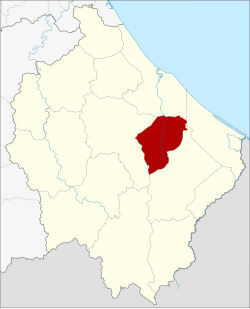
Cho-airong district
|
Cho-airong เจาะ ไอ ร้อง |
|
|---|---|
| Province: | Narathiwat |
| Surface: | 162.7232 km² |
| Residents: | 38,431 (2012) |
| Population density : | 221.2 U / km² |
| ZIP : | 96130 |
| Geocode : | 9613 |
| map | |

|
|
Amphoe Cho-airong ( Thai อำเภอ เจาะ ไอ ร้อง ) is a district ( Amphoe - Administrative District) of the Narathiwat Province . The province of Narathiwat is located in the southeast of the southern region of Thailand on the border with Malaysia.
geography
Neighboring counties and areas are (clockwise from north): Amphoe Mueang Narathiwat , Tak Bai , Su-ngai Padi, and Ra-ngae . All Amphoe are in Narathiwat Province.
history
Cho-aiong was initially set up as a small district ( King Amphoe ) on May 31, 1993 , by separating three tambon from the Amphoe Ra-ngae . On December 5, 1996, Cho-airong was granted full amphoe status.
administration
Provincial Administration
Amphoe Waeng is divided into three subdistricts ( tambon ) , which are further subdivided into 33 village communities ( muban ) .
| No. | Surname | Thai | Villages | Pop. |
|---|---|---|---|---|
| 1. | Chuap | จวบ | 8th | 11.5630 |
| 2. | Bukit | บู กิ ต | 14th | 17,625 |
| 3. | Maruebo Ok | มะ รือ โบ ออก | 11 | 9,276 |
Local administration
Each of the three tambon is administered by a "tambon administration organization" (TAO, องค์การ บริหาร ส่วน ตำบล ).
Web links
Individual evidence
- ↑ ประกาศ กระทรวง มหาดไทย เรื่อง แบ่ง เขต ท้องที่ อำเภอ ระแงะ จังหวัด นราธิวาส ตั้ง เป็น กิ่ง อำเภอ เจาะ ไอ ร้อง (PDF) Royal Gazette, Volume 110, Edition 74 ง of June 8, 1993, p. 15 (in Thai)
- ↑ พระราชกฤษฎีกา ตั้ง อำเภอ เหนือ คลอง อำเภอ นา ยาย อาม อำเภอ ท่า ตะเกียบ อำเภอ ขุน ตาล อำเภอ แม่ ฟ้า หลวง อำเภอ แม่ ลาว อำเภอ รั ษ ฎา อำเภอ อำเภอ พุทธ มณฑล อำเภอ วัง วัง น้ำ เขียว อำเภอ เจาะ ไอ ร้อง อำเภอ ชำนิ อำเภอ โนน ดินแดง อำเภอ ปาง สนธิ อำเภอ อำเภอ อำเภอ อำเภอ อำเภอ อำเภอ อำเภอ หนอง ม่วง อำเภอ เบญจ ลัก ษ์ อำเภอ โพน นา แก้ว อำเภอ บุ่ง คล้า อำเภอ ดอน มดแดง และ อำเภอ ลือ อำนาจ พ.ศ. ๒๕๓๙ (PDF) Royal Gazette, Volume 113, Ed. 62 ก of November 20, 1996, pp. 5–8 (in Thai)
- ↑ Population statistics 2012 . Department of Provincial Administration. Retrieved July 7, 2014.
Coordinates: 6 ° 12 ' N , 101 ° 51' E