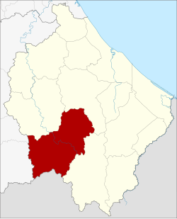
Amphoe Chanae
|
Chanae จะ แนะ |
|
|---|---|
| Province: | Narathiwat |
| Surface: | 607.2 km² |
| Residents: | 35,663 (2012) |
| Population density : | 51.6 U / km² |
| ZIP : | 96220 |
| Geocode : | 9612 |
| map | |

|
|
Amphoe Chanae ( Thai : อำเภอ จะ แนะ ) is a district ( Amphoe - administrative district) in the south of Narathiwat Province . The province of Narathiwat is located in the southeast of the southern region of Thailand on the border with Malaysia.
etymology
Chanae is the Malay name of a local species of Colocasia .
geography
Neighboring counties and areas are (clockwise from west): Betong and Than To district of Yala Province , Sisakhon , Ra-ngae and Sukhirin district of Narathiwat Province, and Kelantan State of Malaysia .
history
Chanae was set up as a subdistrict ( King Amphoe ) on July 15, 1983 , by separating the Tambon Dusongyo and Chanae from the Amphoe Ra-ngae . On January 1, 1988, Chanae officially got full amphoe status.
administration
Provincial Administration
Amphoe Chanae is divided into four sub-districts ( tambon ) , which are further subdivided into 29 village communities ( muban ) .
| No. | Surname | Thai | Villages | Pop. |
|---|---|---|---|---|
| 1. | Chanae | จะ แนะ | 10 | 12,932 |
| 2. | Dusongyo | ดุ ซ ง ญ อ | 8th | 9,532 |
| 3. | Phadung Mat | ผดุง มาตร | 6th | 6.159 |
| 4th | Chang Phueak | ช้างเผือก | 5 | 7,040 |
Local administration
Each of the four tambon is administered by a "tambon administration organization" (TAO, องค์การ บริหาร ส่วน ตำบล ).
Web links
- More details on Amphoe Chanae from amphoe.com (in Thai)
Individual evidence
- ↑ ประกาศ กระทรวง มหาดไทย เรื่อง แบ่ง ท้องที่ อำเภอ ระแงะ จังหวัด นราธิวาส ตั้ง เป็น กิ่ง อำเภอ จะ แนะ (PDF) Royal Gazette, Volume 100, Ed. 114 ง of July 12, 1983, p. 2233 (in Thai)
- ↑ พระราชกฤษฎีกา ตั้ง อำเภอ นาม น อำเภอ พระยืน อำเภอ หนองบัว ระ เหว อำเภอ บ้านเหลื่อม อำเภอ จะ แนะ อำเภอ หนอง หงส์ อำเภอ นา โพธิ์ อำเภอ เกาะยาว อำเภอ อำเภอ แกดำ อำเภอ สระ โบสถ์ อำเภอ อำเภอ โนน คูณ อำเภอ ควนโดน อำเภอ ไชยวาน อำเภอ หนอง แสง และ อำเภอ ตาล สุม พ.ศ. ๒๕๓๐ (PDF) Royal Gazette, Volume 104, Ed. 278 ก ฉบับ พิเศษ (special) from December 31, 1987, pp. 33–37 (in Thai)
- ↑ Population statistics 2012 . Department of Provincial Administration. Retrieved July 7, 2014.
Coordinates: 6 ° 6 ' N , 101 ° 42' E