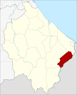
Su-ngai Kolok district
|
Amphoe Su-ngai Kolok อำเภอ สุ ไห ง โก - ลก |
|
|---|---|
| Province: | Narathiwat |
| Surface: | 138.3 km² |
| Residents: | 75,753 (2012) |
| Population density : | 504.4 U / km² |
| ZIP : | 96120 |
| Geocode : | 9610 |
| map | |

|
|
Amphoe Su-ngai Kolok ( Thai อำเภอ สุ ไห ง โก - ลก ) is a district ( amphoe - administrative district) in the east of Narathiwat Province . The Narathiwat Province is located in the southern region of Thailand .
geography
Neighboring counties (clockwise from southwest): Amphoe Waeng , Su-ngai Padi, and Tak Bai in Narathiwat Province. In the southeast is the Kelantan state of Malaysia .
history
The Tambon Su-ngai Kolok was on 1 July 1948 by the government, first as a minor district ( King Amphoe ) set up by the Tambon Su-ngai Kolok, Puyo and Pasemat of Amphoe Su-ngai Padi and Tambon Muno of Amphoe Tak Bai separated were. In 1953 it was granted full amphoe status.
traffic
- Route network of the SRT ( State Railway of Thailand ): In the Amphoe Su-ngai Kolok is the terminus of the south line from Bangkok to the border with Malaysia . The train station is in close proximity to the border, so rail travelers only have to walk a short distance across a bridge for border clearance to enter Kota Bahru , Malaysia.
Attractions
- San Chao Mae Tomo ( ศาล เจ้าแม่ โต๊ะ โมะ ) - Shrine of the goddess Chao Mae Tomo; originally laid out in the Su Khirin district , villagers brought it to the Su-ngai Kolok district, where it is venerated by many residents, including Malays of Chinese descent.
administration
Provincial Administration
Amphoe Su-ngai Kolok is divided into four communities ( tambon ) , which in turn are divided into 19 villages ( muban ) .
| No. | Surname | Thai | Villages | Pop. |
|---|---|---|---|---|
| 1. | Su-ngai Kolok | สุ ไห ง โก - ลก | 1 | 41,552 |
| 2. | Pasemat | ปา เส มั ส | 7th | 18,583 |
| 3. | Muno | มู โนะ | 5 | 9.314 |
| 4th | Puyo | ปู โยะ | 6th | 6,304 |
Local administration
Su-ngai Kolok ( เทศบาล เมือง สุ ไห ง โก - ลก ) is a city ( Thesaban Mueang ) in the district, it consists of the entire tambon Su-ngai Kolok.
There is a small town ( Thesaban Tambon ) in the district:
- Pasemat ( เทศบาล ตำบล ปา เส มั ส ) consists of the entire Tambon Pasemat.
The other two tambon are each managed by a “tambon administration organization” (TAO, องค์การ บริหาร ส่วน ตำบล ).
Web links
- More details on the Su-ngai Kolok (in Thai) Amphoe from amphoe.com
Individual evidence
- ↑ ประกาศ กระทรวง มหาดไทย เรื่อง ยก ฐานะ ตำบล ขึ้น เป็น กิ่ง อำเภอ Royal Gazette Vol. 64, Ed. 60 ง \ of December 9, 1947, pp. 3288–3293 (in Thai)
- ↑ พระราชกฤษฎีกา จัดตั้ง อำเภอ จักราช อำเภอ สัต ต หีบ อำเภอ ศรีสงคราม อำเภอ ชะอวด อำเภอ หนองแซง อำเภอ ภาชี อำเภอ เขา ไชย สน อำเภอ ชุมพลบุรี อำเภอ วาริชภูมิ อำเภอ สบปราบ สบปราบ และ อำเภอ สุไหงโกลก พ.ศ. ๒๔๙๖ Royal Gazette, Vol. 70, Issue 17 ก March 10, 1953, pp. 368–371 (in Thai)
- ↑ Population statistics 2012 . Department of Provincial Administration. Retrieved July 7, 2014.
Coordinates: 6 ° 2 ′ N , 101 ° 58 ′ E