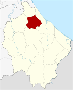
Yi-ngo district
|
Amphoe Yi-ngo อำเภอ ยี่งอ |
|
|---|---|
| Province: | Narathiwat |
| Surface: | 200.516 km² |
| Residents: | 43,820 (2005) |
| Population density : | 202.9 U / km² |
| ZIP : | 96180 |
| Geocode : | 9604 |
| map | |

|
|
Amphoe Yi-ngo ( Thai : อำเภอ ยี่งอ ) is a district ( Amphoe - administrative district) of the Narathiwat Province . The province of Narathiwat is located in the southeast of the southern region of Thailand on the border with Malaysia .
geography
Neighboring counties and areas are (clockwise from north): Amphoe Bacho , Mueang Narathiwat , Ra-ngae, and Rueso . All Amphoe are in Narathiwat Province.
history
Yi-ngo was originally a district in Sai Buri Province. In 1909 he was assigned to Bang Nara Province, now Narathiwat.
administration
Provincial Administration
Amphoe Yi-ngo is divided into six subdistricts ( tambon ) , which are further subdivided into 40 village communities ( muban ) .
| No. | Surname | Thai | Muban | Pop. |
|---|---|---|---|---|
| 1. | Yi-ngo | ยี่งอ | 7th | 9,578 |
| 2. | Lahan | ละ หาร | 8th | 7,848 |
| 3. | Cho Bo | จอ เบาะ | 9 | 8,190 |
| 4th | Lubo Baya | ลุ โบะ บา ยะ | 6th | 4,443 |
| 5. | Lubo Buesa | ลุ โบะ บื อ ซา | 5 | 4,911 |
| 6th | Tapoyo | ตะ ปอ เยาะ | 5 | 8,850 |
Local administration
Yi-ngo ( เทศบาล ตำบล ยี่งอ ) is a small town ( Thesaban Tambon ) in the district, it consists of parts of the Tambon Yi-ngo.
There are also six “tambon administration organizations” (TAO, องค์การ บริหาร ส่วน ตำบล ) for the tambon or the parts of tambon in the county that do not belong to any town.
Individual evidence
- ↑ แจ้ง ความ กระทรวง มหาดไทย เรื่อง โอน อำเภอ ยี่งอ ซึ่ง ขึ้น เมือง สายบุรี ไป ขึ้น จังหวัด บาง นรา ใน มณฑล ปัตตานี ยก กิ่ง อำเภอ จำปา กอ ตั้ง ตั้ง อำเภอ จำปา กอ ขึ้น เมือง สายบุรี . In: Royal Gazette . 26, No. 0 ง , December 5, 1909, p. 1950.
- ↑ Population statistics 2012 . Department of Provincial Administration. Retrieved July 7, 2014.
Web links
Coordinates: 6 ° 24 ' N , 101 ° 42' E