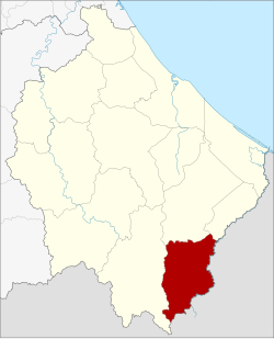
Amphoe Waeng
|
Waeng แว้ง |
|
|---|---|
| Province: | Narathiwat |
| Surface: | 347.3 km² |
| Residents: | 51,653 (2012) |
| Population density : | 136.2 U / km² |
| ZIP : | 96160 |
| Geocode : | 9608 |
| map | |

|
|
Amphoe Waeng ( อำเภอ แว้ง ) is the southernmost administrative district ( Amphoe - Administrative District) of Narathiwat Province . The province of Narathiwat is located in the southeast of the southern region of Thailand on the border with Malaysia.
geography
Neighboring counties and areas are (clockwise from west): Sukhirin Amphoe , Su-ngai Padi, and Su-ngai Kolok in Narathiwat Province. In the south lies the Kelantan state of Malaysia .
In the village of Ban Buketaan on the Thai-Malaysian border there is the possibility of crossing the border to Bukit Bunga, a city in Malaysia.
Part of the Hala-Bala Wildlife Reserve is located in the district.
history
The district goes back to the Tomo ( โต๊ะ โมะ ) district, which was subordinate to Mueang Ra-ngae. The village grew quickly as there was a gold mine here. In 1935, a small district ( King Amphoe ) named Pa Cho (Thai: ปา โจ ) was established, which contained the central part of Tomo. In 1939 it was renamed Tomo, the associated upper district in Waeng. In 1953 the small district of Tomo was merged with Waeng as tambon . In 1957 Tomo was merged with Tambon Samong, which were then separated together in 1977 to create Amphoe Sukhirin .
Attractions
- Hala-Bala Wildlife Reserve - near the border between Thailand and Malaysia situated nature park with about 434 square kilometers area
- Sirindhorn Waterfall - about 7 km from Amphoe Waeng, waterfall and rapids named after Princess Maha Chakri Sirindhorn
administration
Provincial Administration
Amphoe Waeng is divided into six subdistricts ( tambon ) , which are further subdivided into 45 village communities ( muban ) .
| No. | Surname | Thai | Muban | Pop. |
|---|---|---|---|---|
| 1. | Waeng | แว้ง | 7th | 14,324 |
| 2. | Kayu Khla | กา ยู ค ละ | 9 | 7,712 |
| 3. | Kholo | ฆ อ เลาะ | 7th | 6,838 |
| 4th | Lochut | โละ จู ด | 8th | 11,749 |
| 5. | Mae Dong | แม่ ดง | 7th | 6,600 |
| 6th | Erawan | เอราวัณ | 7th | 4,430 |
Local administration
There are two small towns ( Thesaban Tambon ) in the county:
- Waeng (Thai: เทศบาล ตำบล แว้ง ) consists of parts of the Tambon Waeng,
- Buketa (Thai: เทศบาล ตำบล บู เก๊ะ ตา ) consists of parts of the Tambon Lochut.
There are also six “tambon administration organizations” (TAO, องค์การ บริหาร ส่วน ตำบล ) for the tambon or the parts of tambon in the county that do not belong to any town.
Web links
- More details on Amphoe Waeng from amphoe.com (in Thai)
Individual evidence
- ↑ ประกาศ กระทรวง มหาดไทย เรื่อง ตั้ง กิ่ง อำเภอ ปา โจ (PDF) Royal Gazette, Volume 52, Issue 0 ง of November 17, 1935, p. 2501 (in Thai)
- ↑ พระราชกฤษฎีกา เปลี่ยน นาม อำเภอ กิ่ง อำเภอ และ ตำบล บาง แห่ง พุทธศักราช ๒๔๘๒ (PDF) Royal Gazette, Volume 56, Ed. 0 ก of April 17, 1939, pp. 354–364 (in Thai)
- ↑ ประกาศ กระทรวง มหาดไทย เรื่อง ยุบ กิ่ง อำเภอ โต๊ะ โมะ อำเภอ แว้ง จังหวัด นราธิวาส (PDF) Royal Gazette, Volume 70, Issue 56 ง of September 1, 1953, p. 3062 (in Thai)
- ↑ ประกาศ กระทรวง มหาดไทย เรื่อง ยุบ และ เปลี่ยนแปลง เขต ตำบล ใน ท้องที่ อำเภอ แว้ง จังหวัด นราธิวาส (PDF) Royal Gazette, Volume 74, Issue 25 ง of March 12, 1957, p. 679 (in Thai)
- ↑ Population statistics 2012 . Department of Provincial Administration. Retrieved July 7, 2014.
Coordinates: 5 ° 56 ' N , 101 ° 53' E