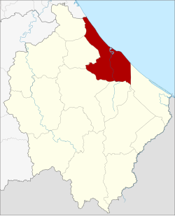
Amphoe Mueang Narathiwat
|
Amphoe Mueang Narathiwat อำเภอ เมือง นราธิวาส |
|
|---|---|
| Province: | Narathiwat |
| Surface: | 305.115 km² |
| Residents: | 117,949 (2012) |
| Population density : | 356.1 U / km² |
| ZIP : | 96000 |
| Geocode : | 9601 |
| map | |

|
|
Amphoe Mueang Narathiwat ( Thai อำเภอ เมือง นราธิวาส ) is a district ( amphoe ) in the province of Narathiwat . The Narathiwat Province is located in the extreme southeast of the southern region of Thailand .
The capital of the county is Narathiwat .
geography
Neighboring counties are (clockwise from southeast): Amphoe Tak Bai , Cho-airong , Ra-ngae , Yi-ngo and Bacho of Narathiwat Province and Amphoe Mai Kaen of Pattani Province . To the east is the Gulf of Thailand .
history
In the area of the Mueang Narathiwat there was originally a village with the name Menara ( Malay منارة , minaret ' ), which belonged to the autonomous Sultanate of Patani or, after its defeat by the Siamese King Rama I in 1809, to the semi-autonomous province of Mueang Sai Buri . It was later promoted to a tambon and assigned to the Mueang Ra-ngae . It was not until 1906 - during the reign of King Chulalongkorn (Rama V) - subjected to the Siamese central administration. As a result of the Anglo-Siamese Treaty of 1909, the area remained with Siam (now Thailand) and was thus separated from the nearby Malay sultanates, which came under the British protectorate as Unfederated Malay States (and now belong to the independent state of Malaysia ).
As the Tambon Menara grew, it was decided to move the administration from Tambon Tanyong Mat to Menara and to promote the Tambon Menara to a province (Mueang) called Bang Nara ( บาง นรา ). In 1915 the city was renamed Narathiwat, but in 1917 the county was renamed Bang Nara again. Finally, in 1938, the name of the county was changed to Mueang Narathiwat.
Amphoe Mueang Narathiwat belongs to the area of action of Muslim-Malay separatists who are calling for an affiliation to Malaysia or the independence of a Patani Sultanate.
education
The Princess of Naradhiwas University is located in the Amphoe Mueang Narathiwat .
traffic
The Narathiwat Regional Airport is located in this district .
administration
Provincial Administration
Amphoe Mueang Narathiwat is divided into seven tambon (communities), which in turn are divided into 57 muban (villages):
| No. | Surname | Thai | Muban | Pop. |
|---|---|---|---|---|
| 1. | Bang Nak | บางนา ค | - | 41,298 |
| 2. | Lam Phu | ลำ ภู | 11 | 12,252 |
| 3. | Manang Tayo | มะ นั ง ตาย อ | 7th | 8,455 |
| 4th | Bang Po | บาง ปอ | 8th | 10,557 |
| 5. | Kaluwo | กะ ลุ วอ | 7th | 9,330 |
| 6th | Kaluwo Nuea | กะ ลุ วอ เหนือ | 12 | 15,647 |
| 7th | Khok Khian | โคก เคียน | 12 | 20,410 |
Local administration
The city of Narathiwat is a city commune ( Thesaban Mueang ) in the district, it consists of the entire Tambon Bang Nak.
There is also a small town commune ( Thesaban Tambon ):
- Kaluwo Nuea ( เทศบาล ตำบล กะ ลุ วอ เหนือ ) consists of the entire Tambon Kaluwo Nuea.
There are also five tambon administrative offices in the county for those tambon that do not belong to any town.
Individual evidence
- ↑ ประกาศ เปลี่ยน ชื่อ เมือง บาง นรา เป น เมือง นราธิวาส . In: Royal Gazette . 32, No. 0 ก , August 8, 1915, p. 145.
- ↑ ประกาศ กระทรวง มหาดไทย เรื่อง เปลี่ยน ชื่อ อำเภอ . In: Royal Gazette . 34, No. 0 ก , April 29, 1917, pp. 40-68.
- ↑ พระราชกฤษฎีกา เปลี่ยน นาม จังหวัด และ อำเภอ บาง แห่ง พุทธศักราช ๒๔๘๑ . In: Royal Gazette . 55, No. 0 ก , November 14, 1938, pp. 658-666.
- ↑ Population statistics 2012 . Department of Provincial Administration. Retrieved July 7, 2014.
Web links
Coordinates: 6 ° 26 ' N , 101 ° 50' E