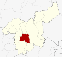
Amphoe Mueang Saraburi
|
Amphoe Mueang Saraburi อำเภอ เมือง สระบุรี |
|
|---|---|
| Province: | Saraburi |
| Surface: | 301.6 km² |
| Residents: | 118,124 (2013) |
| Population density : | 351.8 U / km² |
| ZIP : | 18000 |
| Geocode : | 1901 |
| map | |

|
|
Amphoe Mueang Saraburi ( Thai : อำเภอ เมือง สระบุรี ) is a district ( Amphoe - Administrative District) in the Saraburi Province . Saraburi Province is located in the northeast of the central region of Thailand .
geography
Neighboring counties (clockwise from the north): Amphoe Chaloem Phra Kiat , Amphoe Kaeng Khoi , Amphoe Wihan Daeng , Amphoe Nong Khae , Amphoe Nong Saeng and Amphoe Sao Hai - all of them are in Saraburi Province.
history
When the Northeast Line of the SRT ( State Railway of Thailand ) was built in 1896, and it passed Tambon Pak Phriao, the Governor of Saraburi, Phraya Phichai Ronnarong Songkhram, moved the main district of Saraburi Province from Sao Hai to this area.
administration
Provincial Administration
The district of Mueang Saraburi is divided into eleven tambon ("sub-districts" or "municipalities"), which are further subdivided into 77 muban ("villages").
| No. | Surname | Thai | Muban | Pop. |
|---|---|---|---|---|
| 1. | Pak Phriao | ปาก เพรียว | - | 62,632 |
| 5. | Dao Rueang | ดาวเรือง | 7th | 3,249 |
| 6th | Well, Chong | นา โฉ ง | 3 | 1,252 |
| 7th | Khok Sawang | โคก สว่าง | 11 | 4,569 |
| 8th. | Nong No. | หนอง โน | 11 | 3,993 |
| 9. | Nong Yao | หนอง ยาว | 10 | 8,597 |
| 10. | Pak Khao San | ปาก ข้าวสาร | 4th | 7,750 |
| 11. | Nong Pla Lai | หนอง ปลา ไหล | 9 | 11,944 |
| 12. | Kut Nok Plao | กุด นก เปล้า | 8th | 5,378 |
| 13. | Taling Chan | ตลิ่งชัน | 8th | 4,640 |
| 14th | Takut | ตะ กุด | 6th | 4.120 |
Local administration
There is one commune with "city" status ( Thesaban Mueang ) in the district:
- Saraburi (Thai: เทศบาล เมือง สระบุรี ) consisting of the complete Tambon Pak Phriao.
There are three municipalities with "small town" status ( Thesaban Tambon ) in the district:
- Pok Paek (Thai: เทศบาล ตำบล ป๊อก แป๊ ก ) consisting of parts of the Tambon Nong No.
- Kut Nok Plao (Thai: เทศบาล ตำบล กุด นก เปล้า ) consisting of the complete tambon Kut Nok Plao.
- Takut (Thai: เทศบาล ตำบล ตะ กุด ) consisting of the complete tambon Takut.
In addition, there are seven " Tambon Administration Organizations " ( องค์การ บริหาร ส่วน ตำบล - Tambon Administrative Organizations, TAO)
- Dao Rueang (Thai: องค์การ บริหาร ส่วน ตำบล ดาวเรือง ) consisting of the complete Tambon Dao Rueang, Na Chong.
- Khok Sawang (Thai: องค์การ บริหาร ส่วน ตำบล โคก สว่าง ) consisting of the complete tambon Khok Sawang.
- Nong No (Thai: องค์การ บริหาร ส่วน ตำบล หนอง โน ) consisting of parts of the Tambon Nong No.
- Nong Yao (Thai: องค์การ บริหาร ส่วน ตำบล หนอง ยาว ) consisting of the complete tambon Nong Yao.
- Pak Khao San (Thai: องค์การ บริหาร ส่วน ตำบล ปาก ข้าวสาร ) consisting of the complete Tambon Pak Khao San.
- Nong Pla Lai (Thai: องค์การ บริหาร ส่วน ตำบล หนอง ปลา ไหล ) consisting of the complete tambon Nong Pla Lai.
- Taling Chan (Thai: องค์การ บริหาร ส่วน ตำบล ตลิ่งชัน ) consisting of the complete Tambon Taling Chan.
Individual evidence
- ↑ 2013 population statistics ( Thai ) Department of Provincial Administration. Retrieved September 4, 2014.
Web links
Coordinates: 14 ° 32 ' N , 100 ° 55' E
