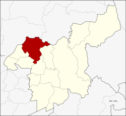
Amphoe Phra Phutthabat
|
Phra Phutthabat พระพุทธบาท |
|
|---|---|
| Province: | Saraburi |
| Surface: | 287.1 km² |
| Residents: | 63,755 (2012) |
| Population density : | 245.1 U / km² |
| ZIP : | 18120 |
| Geocode : | 1909 |
| map | |

|
|
Amphoe Phra Phutthabat (in Thai : อำเภอ พระพุทธบาท ) is a district ( Amphoe - administrative district) in the province of Saraburi . The Saraburi Province is located in the central region of Thailand .
The name of the district comes from Wat Phra Phutthabat ( temple with the Buddha's footprint ). Here in the 17th century a hunter found a depression in a rock that looked like a large footprint. On behalf of the king, wise men then visited this place and declared it to be the “sacred footprint of the Buddha”. A magnificent mondop protects the sanctuary today.
geography
The neighboring districts are (clockwise from north): Mueang Lop Buri and Phatthana Nikhom of Lop Buri Province , furthermore Amphoe Chaloem Phra Kiat , Amphoe Sao Hai , Amphoe Ban Mo and Amphoe Nong Don of Saraburi Province.
Attractions
- Wat Phra Phutthabat - the temple with the Buddha's footprint is one of the few important temples in the country that have been awarded the royal title of Ratchavoramahaviharn . On a hill there is a small, richly decorated mondop in which the highly revered footprint can be admired.
- Wat Tham Krabok - another world famous temple nearby, known for both a refugee camp for Hmong displaced persons and its drug rehabilitation program. ( See also: Saraburi (province) )
administration
Provincial Administration
The district of Phra Phutthabat is divided into nine tambon ("subdistricts" or "communities"), which are further subdivided into 68 muban ("villages").
| No. | Surname | Thai | Muban | Pop. |
|---|---|---|---|---|
| 1. | Phra Phutthabat | พระพุทธบาท | - | 12,369 |
| 2. | Khun Khlon | ขุน โขลน | - | 14,313 |
| 3. | Than Kasem | ธาร เกษม | 8th | 10,818 |
| 4th | Well Yao | นา ยาว | 7th | 3,982 |
| 5. | Phu Kham Chan | พุ คำ จาน | 9 | 3,734 |
| 6th | Khao Wong | เขาวง | 9 | 3,641 |
| 7th | Huai Pa Wai | ห้วย ป่า หวาย | 14th | 4,644 |
| 8th. | Phu Krang | พุก ร่าง | 9 | 6.178 |
| 9. | Nong Kae | หนอง แก | 12 | 4,305 |
Local administration
There is one commune with "city" status ( Thesaban Mueang ) in the district:
- Phra Phutthabat (Thai: เทศบาล เมือง พระพุทธบาท ) consisting of the complete Tambon Phra Phutthabat, Khun Khlon and the parts of the Tambon Than Kasem, Phu Kham Chan.
There are five municipalities with "small town" status ( Thesaban Tambon ) in the district:
- Than Kasem (Thai: เทศบาล ตำบล ธาร เกษม ) consisting of parts of the Tambon Than Kasem.
- Na Yao (Thai: เทศบาล ตำบล นา ยาว ) consisting of the complete tambon Na Yao.
- Huai Pa Wai (Thai: เทศบาล ตำบล ห้วย ป่า หวาย ) consisting of the complete tambon Huai Pa Wai.
- Nong Kae (Thai: เทศบาล ตำบล หนอง แก ) consisting of the complete Tambon Nong Kae.
- Phu Krang (Thai: เทศบาล ตำบล พุก ร่าง ) consisting of the complete Tambon Phu Krang.
There are also two " tambon administration organizations " ( องค์การ บริหาร ส่วน ตำบล - Tambon Administrative Organizations, TAO)
- Phu Kham Chan (Thai: องค์การ บริหาร ส่วน ตำบล พุ คำ จาน ) consisting of parts of the Tambon Phu Kham Chan.
- Khao Wong (Thai: องค์การ บริหาร ส่วน ตำบล เขาวง ) consisting of the complete Tambon Khao Wong.
Individual evidence
- ↑ 2013 population statistics ( Thai ) Department of Provincial Administration. Retrieved September 6, 2014.
Web links
- Further information on Amphoe Phra Phutthabat from amphoe.com (in Thai)
- Information about the Wat Tham Krabok temple (in German)
- Travel report to Wat Phra Putthabat near Saraburi
Coordinates: 14 ° 44 ' N , 100 ° 48' E

