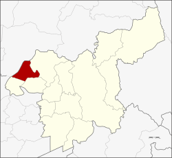
Amphoe Nong Don
|
Nong Don หนองโดน |
|
|---|---|
| Province: | Saraburi |
| Surface: | 88.07 km² |
| Residents: | 14,238 (2013) |
| Population density : | 157.5 U / km² |
| ZIP : | 18190 |
| Geocode : | 1908 |
| map | |

|
|
Amphoe Nong Don ( Thai : อำเภอ หนองโดน ) is a district ( Amphoe - administrative district) in the northwestern part of Saraburi Province . The Saraburi Province is located in the central region of Thailand .
geography
Neighboring districts (clockwise from the north): Amphoe Mueang Lop Buri of the Province of Lop Buri and Amphoe Phra Phutthabat , Amphoe Ban Mo and Amphoe Don Phut of the Province of Saraburi.
history
About ten kilometers from Bang Khamot in today's Amphoe Ban Mo is a large pond with a large kradon tree ( Careya sphaerica Roxb .; ต้น กระโดน ). Immigrants from Dong Noi, Kokko and Mueang Lop Buri founded a village there, which they called Ban Nong Kradon (short: Ban Nong Don).
As the village grew, the government separated the three Tambon Nong Don, Ban Klap and Don Thong from the Ban Mo district on July 15, 1968 in order to establish a new "branch circle" ( King Amphoe ) . On August 21, 1975, Nong Don received full Amphoe status.
administration
Provincial Administration
Nong Don County is divided into four tambon ("subdistricts" or "parishes"), which are further subdivided into 34 muban ("villages").
| No. | Surname | Thai | Muban | Pop. |
|---|---|---|---|---|
| 1. | Nong Don | หนองโดน | 11 | 5,593 |
| 2. | Ban Klap | บ้าน กลับ | 10 | 4,270 |
| 3. | Don Thong | ดอน ทอง | 8th | 2,751 |
| 4th | Ban Prong | บ้าน โปร่ง | 5 | 1,624 |
Local administration
There is one municipality with "small town" status ( Thesaban Tambon ) in the district:
- Nong Don (Thai: เทศบาล ตำบล หนองโดน ) consisting of parts of the Tambon Nong Don.
There are also three " tambon administration organizations " ( องค์การ บริหาร ส่วน ตำบล - Tambon Administrative Organizations, TAO)
- Nong Don (Thai: องค์การ บริหาร ส่วน ตำบล หนองโดน ) consisting of parts of the Tambon Nong Don.
- Ban Klap (Thai: องค์การ บริหาร ส่วน ตำบล บ้าน กลับ ) consisting of the complete tambon Ban Klap, Ban Prong.
- Don Thong (Thai: องค์การ บริหาร ส่วน ตำบล ดอน ทอง ) consisting of the complete tambon Don Thong.
Individual evidence
- ↑ ประกาศ กระทรวง มหาดไทย เรื่อง แบ่ง ท้องที่ ตั้ง เป็น กิ่ง อำเภอ Royal Gazette Volume 85, Ed. 63 ง special ( ฉบับ พิเศษ ) of July 12, 1968, p. 3 (in Thai)
- ↑ พระราชกฤษฎีกา ตั้ง อำเภอ แวงน้อย อำเภอ ป่าแดด อำเภอ เรณูนคร อำเภอ คูเมือง อำเภอ คุระบุรี อำเภอ แม่ลาน้อย อำเภอ เสริมงาม อำเภอ อำเภอ ไพรบึง และ อำเภอ หนองโดน พ.ศ. ๒๕๑๘ Royal Gazette Volume 92, ed. 166 ก special ( ฉบับ พิเศษ ) of August 21, 1975, pp. 1–4 (in Thai)
- ↑ 2013 population statistics ( Thai ) Department of Provincial Administration. Retrieved September 6, 2014.
Web links
Coordinates: 14 ° 41 ′ N , 100 ° 42 ′ E
