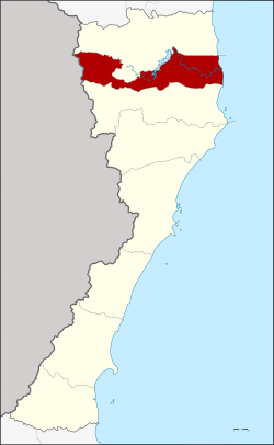
Pran Buri district
|
Pran Buri ปราณบุรี |
|
|---|---|
| Province: | Prachuap Khiri Khan |
| Surface: | 765.370 km² |
| Residents: | 76,294 (2013) |
| Population density : | 98.58 U / km² |
| ZIP : | 77120, 77160, 77220 |
| Geocode : | 7706 |
| map | |

|
|
Amphoe Pran Buri ( Thai : อำเภอ ปราณบุรี ) is a district ( amphoe - administrative district) in the province of Prachuap Khiri Khan . The Prachuap Khiri Khan Province is located in the southern part of the central region of Thailand .
geography
The neighboring amphoe and areas are (clockwise from north): Amphoe Hua Hin , Gulf of Thailand Coast , Amphoe Sam Roi Yot, and the Tanintharyi Division of Myanmar .
The city of Pran Buri is 71 kilometers north of the provincial capital Prachuap Khiri Khan and about 30 kilometers south of the seaside resort of Hua Hin . The district has some beaches that are known for their peaceful atmosphere.
The county's main water resource is the Pranburi River . The mangrove -Forest at its mouth in the Gulf of Thailand is the Pranburi Forest Park (Pran Buri Forest Park) protected. There is a 1 km long beach in the park, which is lined with pine trees. There are also numerous educational hiking trails through mangrove swamps in the park.
history
In the Kingdom of Ayutthaya, Mueang Pran was a city ( Müang ) of a loose group of cities in southern Siam . During the reign of King Mongkut (Rama IV) , the governor of the Mueang Pran had full authority over the administration. During the administrative reform of King Chulalongkorn (Rama V) in 1906 the Mueang Pran, Kamnoed Nopphakhun and Prachuap were merged into a new Mueang Pran Buri. An administration building was established in Tambon Ko Lak (today in the Amphoe Mueang Prachuap Khiri Khan ). King Vajiravudh (Rama VI.) Changed the name of the province from Pran Buri to Prachuap Khiri Khan in 1915, as its center was in the former Mueang Prachuap, the city of Pran Buri and the river of the same name kept their name.
economy
More and more tourist resorts are being built that can be used as alternative quarters if Hua Hin should be too crowded.
In the surrounding area, however, there are still many pineapple plantations where the most delicious fruits in all of Thailand are grown. Canning factories, which export pineapple products to Germany, ensure short transport routes from the fields. Other agricultural products include aloe vera , for example .
Attractions
- Kui Buri National Park (Thai: อุทยานแห่งชาติ กุยบุรี ) - the 969 km² park was opened on October 19, 1989. Worth seeing: some waterfalls and observation of wild elephants.
- Pran Buri Forest Reserve (Thai: วนอุทยาน ปราณบุรี ) - the 3.17 km² reserve was opened on September 30, 1982. The educational hiking trail (“Mangrove Forest Nature Trail” - ทาง เดิน ศึกษา ธรรมชาติ ป่า ชาย เลย ) and the adjacent beach (“Pranburi Forest Park Beach” - ชายหาด วนอุทยาน ปราณบุรี ) are well worth seeing .
administration
Provincial Administration
The district of Pran Buri is divided into six tambon ("sub-districts" or "parishes"), which are further subdivided into 44 muban ("villages").
| No. | Surname | Thai | Muban | Pop. |
|---|---|---|---|---|
| 1. | Pran Buri | ปราณบุรี | 7th | 6,930 |
| 2. | Khao Noi | เขา น้อย | 7th | 28,404 |
| 4th | Pak Nam Pran | ปากน้ำ ปราณ | 5 | 14,497 |
| 7th | Nong Ta Taem | หนอง ตา แต้ม | 12 | 12,193 |
| 8th. | Wang Phong | วังก์ พง | 7th | 11,669 |
| 9. | Khao Chao | เขา จ้าว | 6th | 2,601 |
Note: the missing geocodes 3, 5 and 6 have become the Sam Roi Yot district.
Local administration
There are three municipalities with "small town" status ( Thesaban Tambon ) in the district:
- Khao Noi (Thai: เทศบาล ตำบล เขา น้อย ) consisting of parts of the Tambon Khao Noi.
- Pran Buri (Thai: เทศบาล ตำบล ปราณบุรี ) consisting of the parts of the Tambon Pran Buri, Khao Noi, Nong Ta Taem.
- Pak Nam Pran (Thai: เทศบาล ตำบล ปากน้ำ ปราณ ) consisting of parts of the Tambon Pak Nam Pran.
There are also five " tambon administration organizations " ( องค์การ บริหาร ส่วน ตำบล - Tambon Administrative Organizations, TAO)
- Pran Buri (Thai: องค์การ บริหาร ส่วน ตำบล ปราณบุรี ) consisting of parts of the Tambon Pran Buri.
- Pak Nam Pran (Thai: องค์การ บริหาร ส่วน ตำบล ปากน้ำ ปราณ ) consisting of parts of the Tambon Pak Nam Pran.
- Nong Ta Taem (Thai: องค์การ บริหาร ส่วน ตำบล หนอง ตา แต้ม ) consisting of parts of the Tambon Nong Ta Taem.
- Wang Phong (Thai: องค์การ บริหาร ส่วน ตำบล วังก์ พง ) consisting of the complete tambon Wang Phong.
- Khao Chao (Thai: องค์การ บริหาร ส่วน ตำบล เขา จ้าว ) consisting of the complete Tambon Khao Chao.
Individual evidence
- ↑ 2013 population statistics ( Thai ) Department of Provincial Administration. Retrieved September 11, 2014.
Web links
- More information about Amphoe Pran Buri from amphoe.com (in Thai)
- Map of the city of Pran Buri from Thaiways magazine (in English, last accessed on June 1, 2014)
- Information about Pran Buri Forest Park (in English)
Coordinates: 12 ° 24 ' N , 99 ° 55' E
