Anadyr (river)
|
Anadyr Анадырь |
||
|
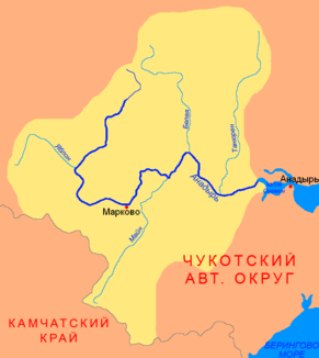
Course and catchment area of the Anadyr |
||
| Data | ||
| Water code | RU : 19050000112119000103602 | |
| location | Chukchi Autonomous Okrug ( Russia ) | |
| River system | Anadyr | |
| source |
Anadyr Plateau 67 ° 3 ′ 54 ″ N , 170 ° 56 ′ 52 ″ E |
|
| muzzle |
Anadyrgolf ( Bering Sea ) coordinates: 64 ° 44 '0 " N , 177 ° 31' 0" E 64 ° 44 '0 " N , 177 ° 31' 0" E |
|
| Mouth height |
0 m
|
|
| length | 1150 km | |
| Catchment area | 191,000 km² | |
| Discharge at the gauge Snezhnoye A Eo : 10,600 km² Location: 254 km above the mouth |
MQ 1958/1988 Mq 1958/1988 |
993 m³ / s 93.7 l / (s km²) |
| Left tributaries | Tschineiwejem , Belaja , Tanjurer | |
| Right tributaries | Jablon , Jeropol , Main | |
| Small towns | Anadyr | |
|
Satellite image of the lower reaches and the estuary |
||
|
The catchment area of the Anadyr with the most important tributaries |
||
The 1146 km long Anadyr ( Russian Ана́дырь ) is a river or stream in Eastern Siberia ( Russia , Asia ).
River course
The Anadyr rises in the Anadyr Plateau southwest of Lake Elgygytgyn . From there it flows in a south-westerly direction. At river kilometer 759 the Anadyr meets the right tributary Jablon . The Anadyr now turns to the east and flows through the Anadyr lowlands until it, finally widening strongly, reaches the city of Anadyr . This lies within its elongated funnel mouth at a narrow point that separates fresh from brackish water. Further down, the Anadyr merges into the Bering Sea .
Landscape image
The landscape at Anadyr is mostly dominated by forest tundra and tundra ; In the tundra, due to the permafrost and the low water content in the soil, no taller-growing plants can develop; instead, lichens , mosses , shrubs and ferns predominate.
The most important tributaries are from the right Jablon, Jeropol and Main , from the left Tschineiwejem , Belaja and Tanjurer .
Catchment area & navigability
The catchment area of the Anadyr, which is largely navigable, covers 191,000 km².
Individual evidence
- ↑ a b Article Anadyr in the Great Soviet Encyclopedia (BSE) , 3rd edition 1969–1978 (Russian)
- ↑ a b Anadyr in the State Water Register of the Russian Federation (Russian)
- ↑ Anadyr at the Snezhnoye gauge - hydrographic data from R-ArcticNET


