Aschenberg (Eastern Ore Mountains)
| Aschenberg | ||
|---|---|---|
|
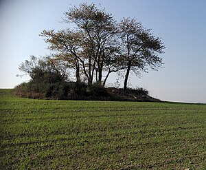
The Aschenberg near Seifersdorf |
||
| height | 383.9 m above sea level HN | |
| location | Germany , Saxony | |
| Mountains | Ore Mountains | |
| Coordinates | 50 ° 56 '18 " N , 13 ° 37' 49" E | |
|
|
||
| rock | Gneiss & Quartzite | |
| particularities | Field island | |
The Aschenberg is located near the town of Dippoldiswalde at the headwaters of the Langegrundbach between the village of Seifersdorf and the Pfarrbusch near Borlas .
Location and surroundings
The Aschenberg is located in the district of Saxon Switzerland-Eastern Ore Mountains in the urban area of Dippoldiswalde, northwest of Seifersdorf and south of Borlas. The mountain, which is surrounded by fields, forms the headwaters of the Langegrundbach, which flows northeast into the Rote Weißeritz , and a brook, unnamed in maps, which flows into the Borlasbach to the west in Borlas .
history
In 1785 the Aschenberg is referred to as Aschen-Berg on sheet 281 of the Berlin copy of the Saxon miles sheets . Its name is based on the Middle High German name for Eschen-Berg (mountain on which ash stands). The mountain served as a trigonometric point from the 19th century to the end of the 20th century . The field path used to run directly past this between the Seifersdorfer parish and the parish bush. The field path that passes below today belongs to the local farmers and serves as a hiking trail between Seiferdorf and Borlas.
Natural space
Ash trees used to grow on the mountain. Today, wild cherries and wild apples grow there, which are surrounded by bushes in the southeastern area.
Web links
- "Aschen-Berg" on sheet 281 in the Berlin copy of the Sächsische Meilenblätter by Friedrich Ludwig Aster from 1795 ( link to the map sheet in the Dresden State and University Library )
- The Aschenberg on the equidistant rate 81 - Section Tharandt - from 1892
Individual evidence
- ↑ Openstreetmap.org , accessed October 24, 2018
- ↑ Friedrich Ludwig Aster: Sächsische Meilenblätter, sheet 281 in the Berlin copy ( link to the map sheet in the Dresden State and University Library )

