Ashland City
| Ashland City | ||
|---|---|---|
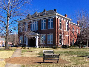
 Cheatham County Courthouse in Ashland City |
||
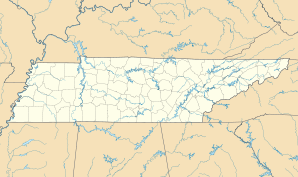
| Location in Tennessee | ||
|
|
||
| Basic data | ||
| Foundation : | 1859 | |
| State : | United States | |
| State : | Tennessee | |
| County : | Cheatham County | |
| Coordinates : | 36 ° 17 ′ N , 87 ° 4 ′ W | |
| Time zone : | Eastern ( UTC − 5 / −4 ) | |
| Residents : | 4,660 (as of 2013 ) | |
| Population density : | 177.9 inhabitants per km 2 | |
| Area : | 28.1 km 2 (approx. 11 mi 2 ) of which 26.2 km 2 (approx. 10 mi 2 ) are land |
|
| Height : | 130 m | |
| Postal code : | 37015 | |
| Area code : | +1 615 | |
| FIPS : | 47-02180 | |
| GNIS ID : | 1304885 | |
| Website : | www.ashlandcitytn.gov | |
Ashland City (also Ashland ) is a city in Cheatham County in the US state of Tennessee .
geography
Ashland City is the largest city in Cheatham County and its administrative seat. The city is located roughly in the center of the county on the flat northeast bank of the Cumberland River , a few kilometers above the confluence with the Harpeth River .
Ashland's geographic coordinates are 36 ° 16 ′ N , 87 ° 3 ′ W (36.267954, −87.054877)
The city is located at the intersection of Tennessee State Route 12 , which connects Ashland City with the capital of Tennessee, Nashville , about 15 miles southeast of Ashland , and Clarksville in the northwest, and Tennessee State Route 49 , which goes northeast to Springfield and Kentucky and westward to Charlotte .
According to the United States Census Bureau , Ashland City has a total area of 28.1 square kilometers, of which 26.2 square kilometers are land and 2.0 square kilometers (= 6.95 percent) are water.
history
Ashland City was founded in 1856 as the county seat of the newly established Cheatham County. The official founding date is 1859. In 1869 the present Cheatham County Courthouse was completed.
The first industrial operation in the area was a forge , which was set up in 1818 by Montgomery Bell on the Harpeth River, a few miles southwest of the present city. In 1835, Samuel Watson founded a flour mill , which later also played an important role in arms production as a powder mill in the American Civil War . The mill was in operation until 1904.
The town's name is derived from either resident Henry Clay , the name Ashland wore, or inspired by the indigenous to the area Ash (english: ash ).
Boxer Caleb Plant was born in Ashland City on July 8, 1992 .
Web links
- The City website (English)
supporting documents
- ^ Mergell, CS Military Map of Middle Tennessee and parts of Tennessee and Adjoining States. np, 1865.
- ↑ Geographic Identifiers: 2010 Census Summary File 1 (G001): Ashland City town, Tennessee ( en ) US Census Bureau, American Factfinder. Retrieved May 22, 2017.
- ^ Ashland City Past ( Memento June 21, 2007 in the Internet Archive ), 2006–2012. Originally published as Goodspeed's History of Cheatham County, Tennessee by the Goodspeed Publishing Company in 1887. Retrieved February 11, 2008.
- ↑ a b James Hallums, Cheatham County. In: The Tennessee Encyclopedia of History and Culture , 2002. Retrieved February 11, 2008.
- ↑ Larry L. Miller: Tennessee place names . Indiana University Press, October 2001, ISBN 978-0-253-21478-2 , p. 9 (accessed November 21, 2011).
