Asopos (Laconia)
|
Asopos Municipality Δημοτική Ενότητα Ασωπού (Ασωπός) |
||
|---|---|---|
|
|
||
| Basic data | ||
| State : |
|
|
| Region : |
Peloponnese
|
|
| Regional District : | Laconia | |
| Municipality : | Monemvasia | |
| Geographic coordinates : | 36 ° 43 ′ N , 22 ° 52 ′ E | |
| Height above d. M .: | 56 m papadianika |
|
| Area : | 94.36 km² | |
| Residents : | 3,840 (2011) | |
| Population density : | 40.7 inhabitants / km² | |
| Code No .: | 430502 | |
| Structure: | 4 local communities | |
| Located in the municipality of Monemvasia and the Laconia regional unit | ||
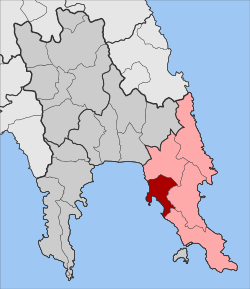
Asopos ( Greek Ασωπός ( m. Sg. )) Is a village in Laconia on the Peloponnese peninsula . Asopos formed an independent municipality until 2010. It was created at the end of 1996 in the course of the Greek community reform from the rural communities Papadianika, Asopos and Finiki, in 1997 the rural community Demonia was incorporated. With the administrative reform in 2010 , Asopos was incorporated into Monemvasia , where it has since been one of five municipal districts.
location
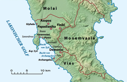
Asopos is located on the eastern coast of the Laconian Gulf between the municipalities of Molai and Vies on the Laconian Peninsula, the eastern of the three "fingers" of the Peloponnese that protrude into the Ionian Sea . The neighboring city to the east is Monemvasia . The northern municipal area is part of the Molai plain, to the south and east the terrain is mountainous and rises to 520 m (Chavalas) . In front of the coast is the Xyli peninsula, which encloses a natural harbor with the bay named after it at Plytra. Further south is another sheltered bay north of Cape Archangelos. In the Middle Ages, the population largely withdrew from the coast to the inland, so that the larger villages are now inland, Asopos, Papadianika and Finiki in the plains, Demonia in the more southern hill country.
history
Traces of two ancient cities with the names Kyparission and Kyparissia were found on the territory of the municipality, which no longer existed in late antiquity. Kyparission, founded by Achaean colonists, seems to be the oldest settlement in the municipality, the younger one, presumably founded by residents of Messenian Kyparissia , is mentioned by Homer and is believed to be north of the Xyli peninsula near Bozas.
The origin of the ancient city of Asopos is believed to have been around the time the Dorians conquered the Peloponnese . The city was probably named after a nearby river, as Asopos was the name of several Greek rivers whose waters were believed to have medicinal properties. The personification of these rivers as the river god Asopos was considered a mythical helper of the god Asclepius . The mention of an Asklepios sanctuary "fifty stadia" (9 km) from Asopos in a place called Hyperteleaton, which is believed to be in a ravine south of today's Finiki, seems to support this thesis.
Pausanias mentions Asopos as one of the 18 cities of the laconic city union of the Erythrolaconians , who pursued the extraction of purple from purple snails . From his description, the position of the coastal town of Plytra emerges as the likely position of this ancient city. Submarine ruins of a town on Kokkines Beach south of Plytra have fueled speculation that the town sank in a major earthquake in AD 375.
The city must have been quite important in Roman times and still existed as a bishopric in Byzantine times. When the Peloponnese was conquered by the Ottoman Empire in 1461 , Asopos was already an insignificant village.
Obviously, the inhabitants of this village withdrew further inland in the early modern period because of the frequent pirate attacks on the coast and founded a new village off the coast, which was initially named Kalyvia ( Greek Καλύβια ). After Crete was conquered by the Ottomans, Cretan refugees settled in the municipality and named the village Kondevianika ( Greek Κοντεβιάνικα ) after the Cretan city Viannos . In 1910 the place took on the ancient name Asopos.
The name of the village Finiki is said to go back to a trading post of the Phoenicians ( Greek Φοίνικες , Finikes ) from the ninth century BC. Until the conquest by the Ottomans, the inhabitants lived in the settlement of Krisa and only retreated to the higher village after the Turkish colonization of the coast.
Demonia was created during the Ottoman period by settlers from various destroyed places and from the island of Kythira . Papadianika was founded by Cretans during the Greco-Turkish War in 1821 and named after the Papadakis family, whose members dominated the village.
Under the old name Kondevianika (Κοντεβιάνικα), the place was recognized as a rural community (kinotita) in 1912 and officially renamed Asopos in 1940. In 1996 Finiki and Papadianika were incorporated and Asopos was raised to a municipality (dimos) , Demonia was incorporated in 1997.
Economy and Infrastructure
The residents of the community traditionally live from agriculture. Above all, the cultivation of olive trees for table olives and for the extraction of olive oil as well as citrus plantations characterize the picture. Other agricultural products of the municipality are tomatoes, melons, various vegetables and grapes, which are also used privately to make wine. The livestock industry is mainly represented by goat breeding. The fishery is also pursued.
Tourism has established itself as the second major economic factor. Although the municipality does not have any outstanding sights, the numerous beautiful beaches attract bathing tourists to the municipality in summer. The coastal towns of Plytra and Archangelos are equipped with a few hotels and holiday apartments and have the appropriate tourist infrastructure. There are mooring options for yachts in the natural harbors of both places. Agrotourism also plays a role .
Community structure
The rural communities, which were independent until 1996, became districts when they were incorporated into Asopos; since 2011 they have formed localities with local representatives in the municipality of Asopos. The population figures in brackets come from the 2011 census.
- Local community Papadianika
- Papadianika (Παπαδιάνικα, 1,657)
- Karavostasi (Καραβοστάσι, 38)
- Plytra (Πλύτρα, 211)
- Local community Asopos
- Asopos (1,023)
- Glyfada (Γλυφάδα, 8)
- Local community Demonia
- Demonia (Δαιμονία, 346)
- Archangelus (Αρχάγγελος, 33)
- Paralia (Παραλία, 85)
- Local community Finiki
- Finiki (Φοινίκι, 416)
- Krisa (Κρισά, 23)
Individual evidence
- ↑ Results of the 2011 census, Greek Statistical Office (ΕΛ.ΣΤΑΤ) ( Memento from June 27, 2015 in the Internet Archive ) (Excel document, 2.6 MB)
- ^ Pausanias: Description of Greece . III.21.7, III.22.9-10.


