
Aue-Oker Canal
| Aue-Oker Canal | ||
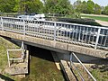
 Deeply incised course of the canal in the area of the Braunschweiger Rieselfelder |
||
| Data | ||
| Water code | DE : 48278 | |
| location | Lower Saxony , Germany | |
| River system | Weser | |
| Drain over | Oker → Aller → Weser → North Sea | |
| Branch from the floodplain | At Wendeburg 52 ° 18 ′ 33 ″ N , 10 ° 22 ′ 51 ″ E |
|
| Source height | 68 m above sea level NHN | |
| muzzle |
Oker bei Hülperode Coordinates: 52 ° 19 ′ 40 ″ N , 10 ° 26 ′ 58 ″ E 52 ° 19 ′ 40 ″ N , 10 ° 26 ′ 58 ″ E |
|
| Mouth height | 63 m above sea level NHN | |
| Height difference | 5 m | |
| Bottom slope | 0.79 ‰ | |
| length | 6.3 km | |
| Catchment area | 8.04 km² | |
| Big cities | Braunschweig | |
| Communities | Wendeburg , Schwülper | |
The Aue-Oker Canal is a six-kilometer-long canal in the north of Braunschweig between the Aue and the Oker , which was cut in the 19th century and is now used as the receiving water for the Braunschweig sewage treatment plant.
Geography and importance
The Aue-Oker Canal begins north of the Mittelland Canal near the canal bridge at canal kilometer 212.645 and serves to relieve the floodplain . As a deep ditch, it runs on the northern edge of the pond landscape in the Braunschweiger Rieselfeldern and is the receiving water of the Braunschweiger Steinhof sewage treatment plant. In this area it is equipped with measuring technology for monitoring. It crosses the B 214 and flows through the nature reserves Braunschweiger Okeraue and Nördliche Okeraue . In front of its confluence with the Oker there is a structure to regulate the damming into the meadows of the Oker floodplain.
history
The construction of the Aue-Oker Canal during the separation , around 1850, is due to flood protection. The locations Wendezelle and Wendeburg should be protected from flooding by draining the excess water into the Oker. Initially, the Aue-Oker-channel chain south of the present Mittellandkanal in black break from Aue and was a culvert conducted under the Mittellandkanal through. After a few years, the culvert silted up, and an inlet into the Mittelland Canal was built to replace the branching off of the Salzgitter branch canal . The beginning of the Aue-Oker Canal on the Aue was re-established north of the Mittelland Canal.
The floodplain crossed under the Mittelland Canal until 1972 in a two-pipe concrete culvert at canal kilometer 212.043, since then in a two-pipe steel culvert at canal kilometer 212.013.
Aue-Oker Canal near Wendeburg
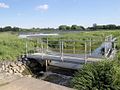
In the outlet area of the Aue-Oker Canal, the water is dammed and a pond landscape is irrigated (NABU area).

Outlet structure of the canal into the Oker with flood protection


