Kellerberg (Meulenwald)
| Kellerberg | ||
|---|---|---|
| height | 448.8 m above sea level NHN | |
| location | at Dierscheid ; District of Bernkastel-Wittlich , Rhineland-Palatinate ( Germany ) | |
| Mountains | Meulenwald ( Eifel ) | |
| Coordinates | 49 ° 53 '40 " N , 6 ° 45' 39" E | |
|
|
||
| particularities | Dierscheid observation tower | |
The Kellerberg is 448.8 m above sea level. NHN the highest elevation in the Eifel part of Meulenwald and the community of Wittlich-Land . It is located near Dierscheid in the Rhineland-Palatinate district of Bernkastel-Wittlich . The Dierscheid observation tower stands on top of it .
geography
location
The Kellerberg rises in the Meulenwald , part of the Moselle Eifel . Its summit is 0.5 km south-southeast of Dierscheid , to whose municipality the mountain belongs, 2.2 km west-north-west of Erlenbach , a district of Hetzerath , and 1.7 km north-north-east of the center of Naurath in the Trier-Saarburg district . The rivers that arise on the mountain include the Weischbach and Orschbach in the east and the Gitzertbach in the south-south-west and the Stahlbach in the west.
In the vicinity of the peaks, the height indication 448.7 m is recorded on topographic maps . On the basement Berg parts of the protected landscape Meulenwald and city forest Trier ( CDDA -No 322963;. Reported in 1990; 132.8046 square kilometers in size).
Natural allocation
The Kellerberg belongs to the natural spatial main unit group Eastern Eifel (No. 27), in the main unit Moseleifel (270) and in the subunit Wittlicher Heckenland (270.6) to the natural area Naurather Horst (270.60). To the west is the Meulenwald subunit (270.7).
Dierscheid observation tower
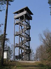
The 21.7 m high Dierscheid observation tower in modern wood and steel construction has stood on the mountain since 1999 . The roofed tower has a triangular floor plan and consists of seven larch logs that are connected with metal struts. The entire construction is braced crosswise on the sides with steel cables. From the viewing platform at a height of 18 m you can see far into the Eifel and Hunsrück - for example to Klausen with the pilgrimage church there.
Web links
Individual evidence
- ↑ a b c Map service of the landscape information system of the Rhineland-Palatinate nature conservation administration (LANIS map) ( notes )
- ↑ Map services of the Federal Agency for Nature Conservation ( information )
- ↑ Lookout tower in Dierscheid (Ingenieurbüro Zosel), accessed on September 23, 2016, from zosel-weinsheim.de
- ↑ Dierscheid, observation tower (Landesforsten Rheinland-Pfalz), accessed on May 23, 2015, on wegezumholz.de

