Three brothers height
| Three brothers height | ||
|---|---|---|
|
Berghotel Drei Brüder Höhe |
||
| height | 688.1 m above sea level NHN | |
| location | Free State of Saxony , Germany | |
| Mountains | Ore Mountains | |
| Coordinates | 50 ° 39 '24 " N , 13 ° 7' 31" E | |
|
|
||
| Type | Hill of the Marienberg plateau | |
| rock | Two mica gneiss | |
| Development | 1883 by the Erzgebirgszweigverein Marienberg | |
| particularities | Dreibrüderhöhe observation tower , radio tower | |
The Dreibrüderhöhe or shortly Brüderhöhe is a 688.1 m above sea level. NHN high mountain west of the city of Marienberg in the central Ore Mountains in the Free State of Saxony .
history
Origin of the name
The name of the mountain was derived from the pit name Alte Drei Brüder , which has its origins in the legend that three brothers from Italy are said to have discovered a silver vein here .
Tourist development
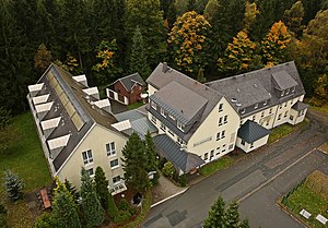
In May 1883 an 18 m high iron observation tower on the Dreibrüderhöhe was inaugurated by the Erzgebirgszweigverein Marienberg, which had been built by the C. Reinsch machine factory from Dresden for a price of around 6000 Reichsmarks. The tower, which was named in 1884 after the deceased wife of the then Prince Georg of Saxony, Princess-Marien-Turm , soon became so popular as a destination that Gustav Loose, a member of the Marienberg Ore Mountain Branch, founded in 1878, moved to the hut house built in 1853/54 Alte Drei Brüder built an inn in 1886. The Berghaus Dreibrüderhöhe was owned by the Loose family until 1977 , when it was sold to the Marienberg building management company and continued to be used as a restaurant until the end of 1985. Then the LPG Marienberg took over the restaurant, which it sold in 1992. In 1992/93 the conversion to the current mountain hotel Drei Brüder Höhe took place . There is a caravan parking space next to the hotel.
The observation tower, on the other hand, was closed for a long time by the building authorities. In addition, he was not far from the restricted area at the military training area. It was therefore torn down and scrapped on March 11, 1977.
The city of Marienberg had a new, 25.4 m high observation tower built on the Dreibrüderhöhe, which was inaugurated on May 12, 1994 and provides a good view of Marienberg and the immediate vicinity.
Approx. A slightly higher radio tower is located 60 m northeast of the tower within a fenced-off military security area .
Location and surroundings
The Dreibrüderhöhe is on the western edge of the Marienberg plateau on the gravel wood. It can be reached by car via a junction from the federal road 171 between Marienberg and Wolkenstein .
Hiking routes to the summit
The Dreibrüderhöhe can be reached on foot via signposted hiking trails from Marienberg, Lauta, Gehringswalde, Wolkenstein or Großrückerswalde. The Eisenach – Budapest mountain hiking trail also passes by.
Web links
Individual evidence
- ↑ a b Map services of the Federal Agency for Nature Conservation ( information )
- ↑ Lookout tower and caravan parking space . ( Memento from April 3, 2015 in the Internet Archive ) On the website of the Berghotel Dreibrüderhöhe


