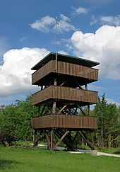
Erbeskopf observation tower
The Erbeskopf observation tower (also called Erbeskopfturm ) is an 11 m high observation tower on the Erbeskopf ( 816.32 m above sea level ), the highest mountain in the Hunsrück , in the district of Bernkastel-Wittlich and in Rhineland-Palatinate, as well as the highest German elevation on the left bank of the Rhine .
Geographical location
The Erbeskopfturm stands in the southwest of the Idarwald on the Erbeskopf in the Saar-Hunsrück Nature Park , about 150 m southwest of the mountain summit. It is located in the area of the Hilscheid municipality, which is around 6 km to the west, also in the district of Bernkastel-Wittlich .
Description and history
Originally a 23 m high stone Kaiser Wilhelm tower built by the Mosel-Hochwald-Hunsrückverein and inaugurated on September 8, 1901, stood at the site of today's observation tower . After 60 years he was blown up on military charges.
In 1971, just outside a restricted military area, today's Erbeskopf Tower was built as a wooden structure on a 6 m by 6 m base with 3 floors and platforms and a tower height of 11 m, the topmost of which is roofed as the main viewing platform. There are metal panels with direction and distance information from visual targets. The tower in need of renovation cannot currently be climbed.
Plans to build another tower continued to exist because the wooden tower was not accepted as a replacement for the blown up Kaiser Wilhelm tower. Because it was not possible to build a higher tower on the Erbeskopf due to the radar facilities, the walk-in sculpture Windklang was built in 2011 as part of the redesign of the summit area around 150 m north of the Erbeskopf tower , which enables unobstructed views to the west and north.
In addition to the Erbeskopf tower there is a weather station of Meteo Media AG .
Opportunities for viewing
The view from the Erbeskopfturm particularly includes the summit area with the sculptures Windklang and Summit Heads of the region installed there in 2011 . The distance view is partially restricted by trees, especially to the west and east. When the weather is clear, distant views north to parts of the Eifel are possible. After the vegetation south of the tower has been cut back, there are also views in this direction over the Saar-Nahe mountainous region with the Schaumberg .
Transport links
The Erbeskopfturm can be reached via the district road 50, which branches off between the Erbeskopf and its neighboring mountain Kahlheid ( 766 m ) from the state road 164 (connects the federal roads 327 in the west and 269 and 422 in the east) to the hanging birch in the district of Birkenfeld , which is a spur road in the district of Bernkastel-Wittlich merges into the K 121. After about 2 km you will find a parking lot for hikers right next to the tower.
Web links
- The Erbeskopfturm and other towers in observation towers on the Hunsrück , on hunsrueck-zeitung.com
Individual evidence
- ↑ a b c d Erbeskopfturm , Hunsrück Association
- ↑ No more all-round view from the Erbeskopf: old tower is in need of repair - renovation before the start of the season. In: volksfreund.de. February 12, 2016, accessed August 8, 2016 .
- ↑ As if the hikers were floating in the middle of the Hunsrück landscape , from February 5, 2010, accessed on August 9, 2013, on volksfreund.de
- ↑ Erbeskopf: Ideas Competition Takes Form , July 23, 2007, accessed on August 9, 2013, on volksfreund.de
literature
- Hunsrückverein (ed.): The Wildenburg and the Erbeskopfturm , yearbook 1962: Sheets for the Moselle, Hochwald and Hunsrück
- Gustav Schellack, in: Hunsrücker Heimatblätter , No. 63, June 1985, pp. 94 to 107
Coordinates: 49 ° 43 ′ 45.5 " N , 7 ° 5 ′ 22.4" E

