Avelas de Caminho
| Avelas de Caminho | ||||||
|---|---|---|---|---|---|---|
|
||||||
| Basic data | ||||||
| Region : | Centro | |||||
| Sub-region : | Aveiro Region | |||||
| District : | Aveiro | |||||
| Concelho : | Anadia | |||||
| Coordinates : | 40 ° 29 ′ N , 8 ° 27 ′ W | |||||
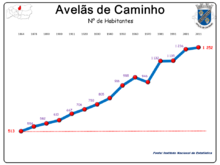
| Residents: | 1252 (as of June 30, 2011) | |||||
| Surface: | 6.45 km² (as of January 1, 2010) | |||||
| Population density : | 194 inhabitants per km² | |||||
| Postal code : | 3780-351 | |||||
| politics | ||||||
| Mayor : | César Henrique de Seabra Rangel e Andrade ( PPD / PSD ) | |||||
| Address of the municipal administration: | Junta de Freguesia de Avelãs de Caminho Rua das Flores 3780-351 Avelãs de Caminho |
|||||
| Website: | www.avelasdecaminho.pt | |||||
Avelãs de Caminho is a place and a municipality in the central region of Portugal .
A cache of the international geocaching community is hidden here.
history
The place is first mentioned by the Romans as the Avellanum region at the mouth of the Rio da Serra , at the time of the first Roman emperor Augustus .
The current town was probably created in the course of the new settlements during the Reconquista . In the 10th century it is as Avelanas noted in the 12th century as Avelanas de Susana and in the next century as Avelanis de Jusanis .
King D. Manuel gave the place as Avelãs do Caminho on November 13, 1514 city rights and made it the seat of a district. Since then, the place has borne the title of a small town ( Vila ).
The place was also the setting of a small episode during the Napoleonic Wars in the Iberian Peninsula . One day after the Battle of Buçaco on September 27, 1810, the defeated French army under Marshal André Masséna in search of the royal connecting road ( Estrada Real ) only met that road in Avelãs de Caminho, in order to follow it south towards the lines from Torres Vedras to march.
In the course of the administrative reforms after the Liberal Revolution in 1822 , the district was dissolved in 1836. Since then Avelãs de Caminho has been a parish in Anadia County.
administration
Avelãs de Caminho is a municipality ( freguesia ) in the district ( concelho ) of Anadia , in the district of Aveiro . 1252 inhabitants live in the municipality (as of June 30, 2011).
The following localities are in the municipality:
- Avelas de Caminho
- Moinho Novo
- Moinhos da Quebrada
Parish partnership
There is a partnership with the French community of Saint-Même-les-Carrières .
Web links
Individual evidence
- ↑ a b www.ine.pt - indicator resident population by place of residence and sex; Decennial in the database of the Instituto Nacional de Estatística
- ↑ Overview of code assignments from Freguesias on epp.eurostat.ec.europa.eu
- ↑ Avelãs de Caminho on www.geocaching.com , accessed February 22, 2016
- ↑ Early history of the Avelãs de Caminho parish on the parish website, accessed February 22, 2016
- ^ History of the municipality of Avelãs de Caminho during the Napoleonic invasions on the municipality's website, accessed on February 22, 2016
- ↑ Entry on Avelãs de Caminho on www.terrasdeportugal.com, accessed on February 22, 2016


