Awanui (Northland)
| Awanui | ||
| Geographical location | ||
|
|
||
| Coordinates | 35 ° 3 ′ S , 173 ° 15 ′ E | |
| Region ISO | NZ-NTL | |
| Country |
|
|
| region | Northland | |
| District | Far North District | |
| Ward | Te Hiku Ward | |
| Residents | 339 (2013) | |
| height | 3 m | |
| Post Code | 0486 | |
| Telephone code | +64 (0) 9 | |
| Photography of the place | ||
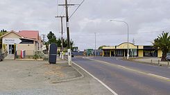
 In the center of the town, the New Zealand State Highway 10 meets State Highway 1 |
||
Awanui is a small town with a river port in the Far North District of Northland on the North Island of New Zealand .
geography
Awanui is about 8 km north of Kaitaia at the base of the Aupōuri Peninsula . It is considered the starting point on the more than 100 km long way to Cape Reinga . In the center of the village, the New Zealand State Highway 10 meets State Highway 1 and a few hundred meters to the north the Awanui River flows through the town in a northerly direction to Rangaunu Bay .
Since the 2001 census, the town's population has decreased continuously. In 2001 there were 369 inhabitants, in 2006 there were 346 and in 2013 only 339 inhabitants.
history
Subritzky family
In early 1868, John Anton Subritzky and his family sold their shares in Maldon , Australia, and took the barquentine Prince Alfred to New Zealand. Arrived in Auckland , they traveled in their own schooner to Houhora and Mount Camel Station , a large estate that belonged to his older brothers, Captain Ludolph Johann and Heinrich Wilhelm.
In a short period of time, the Subritzky family took control of a large part of the land north of Awanui . The site of Awanui was built by them and their extended family, which included both Pākehā and Māori . However, the family's business hub was Mount Camel Station . Their significant influence on the far north of New Zealand spanned over 50 years. They imported cattle and developed their own breed of Shorthorn cattle . They set up a shipping link to Auckland and transported many of the early settler families north. The Subritzkys set up flax mills and began processing the fibers for sale and export. With the beginning of the resin extraction from the Kauri tree , this branch of business contributed to the prosperity of the family and the Northland region until the 20th century .
Shipwreck
When the steamer Elingamite sank on November 5, 1902, the location played a role, as one of the rescue ships started from Awanui and three of the victims were buried there.
economy
In the 1920s, Kauri wood and Kauri resin were brought to the coast from Kaitaia via Awanui .
education
The Awanui School is a primary school for grades 1-6 with a Decile rating of 2 and in 2009 74 students. The Te Rangi Aniwaniwa is a school for the 1st-15th Class with a Decile rating of 1 and 117 students in 2009.
literature
- AH Reed : The Gumdigger - The Story of Kauri Gum . 1948, p. 57 ff . (English).
- FM Keene : To The Northwar . A history of the Mangonui County area, which included the Aupouri Peninsula , Kaitaia and Whangaroa . QSM Bryant Print , Whangarei 1977 (English).
- MRG Subritzky : The Subritzky Legend . A historic publication of New Zealand's first Polish settler family . John Dunmore, Heritage Press , 1990, ISBN 0-908708-20-3 (English).
- MRG Subritzky : Subritzky Shipping - A Heritage of Sail 1843 - 1993 . 2nd Edition. Bay Publishing , 1994, ISBN 0-473-01849-7 (English).
- James N. Bade : The German Connection - New Zealand and German - speaking Europe in the Nineteenth Century . Oxford University Press , Auckland 1996, ISBN 0-19-558283-7 , Part IV: The Contribution of German Settlers to Business and Enterprise in New Zealand - Chapter 22: The Subritzky's (English).
- K. Parker : Kaitaia - Portraits from the Past 1900-1939 . Bridgewater & Top , Kaitaia 1999, ISBN 0-473-05930-4 , Chapter 3: Changes Faces of Transport, Chapter 4: The Many uses of Land, Chapter 20: Regional Potpourri - Houhora Home of the Subritzky and Evans families (English) .
- AI Evans : Tea Tree Berry Kid - The Influence of the Far North . Ed .: Northland Historical Publications Society . 1996, ISBN 0-9597926-7-8 , pp. 3, 7, 17, 32 (English).
Individual evidence
- ↑ a b 2013 Census QuickStats about a place: Awanui . Retrieved May 20, 2017 .
- ↑ Topo250 maps . Land Information New Zealand , accessed January 15, 2017 .
- ^ Northland places in Te Ara Encyclopedia of New Zealand . Retrieved November 11, 2010.
