
Bächlesbach
| Bächlesbach | ||
 The Bächlesbach in the Spessart meadows |
||
| Data | ||
| location |
Spessart
|
|
| River system | Rhine | |
| Drain over | Lohrbach → Aubach → Lohr → Main → Rhine → North Sea | |
| source | Bächlesbrunnen northeast of Heigenbrücken 50 ° 2 ′ 6 ″ N , 9 ° 23 ′ 31 ″ E |
|
| Source height | 315 m above sea level NHN | |
| muzzle | Between Heigenbrücken and Neuhütten in the Lohrbach Coordinates: 50 ° 1 '10 " N , 9 ° 23' 28" E 50 ° 1 '10 " N , 9 ° 23' 28" E |
|
| Mouth height | 255 m above sea level NHN | |
| Height difference | 60 m | |
| Bottom slope | 30 ‰ | |
| length | 2 km | |
| Catchment area | 4.7 km² | |
The Bächlesbach , or also just called Bächles , is a left, approximately 2 km long tributary of the Lohrbach near Heigenbrücken in the district of Aschaffenburg in the Spessart . Its source is the Bächlesbrunnen at the " Great Mariengrotto ".
geography
Bächlesbrunnen

The Bächlesbrunnen is located southeast of the upper end of the Bächlesgrund in the Heinrichsthaler Forest . Here, in 1955, three forest workers built a grotto made of heavy spar stones. The Bächlesbrunnen pours an annual average of around 40 liters per second and is therefore one of the strongest springs in the Spessart.
course
After the water in the Bächlesbrunnen comes to the surface, the course of the brook already divides in the spring socket and both branches move towards the edge of the forest. There they finally reunite and the Bächlesbach now reaches the “ Spessartwiesen ” nature reserve . The stream then flows through the Heigenbrücken Wildlife Park, where wild boars and deer often drink from it. After leaving the wildlife park, the Bächlesbach crosses under the Kahltal-Spessart cycle path and flows into the Lohrbach near a lake .
Flora and fauna
Sources from the red sandstone usually pour acidic water, including the Bächlesbrunnen, so that the mosses , other plants and animals that are characteristic for this can also be found in the Bächlesbach , such as the larvae of the fire salamander .
See also
Picture gallery

The source of the Bächlesbach

The place of the Great Marian Grotto at the source
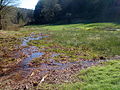
The branching Bächlesbach in the Spessartwiesen


