Sumava Highlands
| Sumava Highlands
Šumavská hornatina
|
|
|---|---|
|
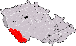
Subgroup Šumavská hornatina (marked in red) |
|
| Highest peak | Velký Javor ( Great Arber ) ( 1456 m nm ) |
| location | Czech Republic |
| part of | Bohemian mass |
| Classification according to | Geomorphological classification of the Czech Republic |
| Coordinates | 49 ° 7 ' N , 13 ° 8' E |
| surface | 4,959 km² |
The Bohemian Forest Highlands ( Czech: Šumavská hornatina) is a geomorphological area in the south of the Bohemian Forest . It is located in the southwest of Bohemia , in the northeast of Bavaria and in northern Austria. In addition to the highest parts of the Bohemian Forest, it also includes the Novohradské Mountains and extensive highlands and foothills. The highest point is the Great Arber in the Bavarian part of the Bohemian Forest. On Czech territory is the Plechý at 1378 m.
In German (Bavarian) territory, it partially overlaps with the Upper Palatinate - Bavarian Forest area , which is defined within the geomorphological division of Germany.
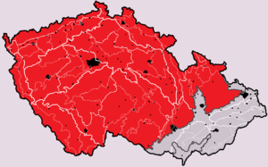
Geomorphological classification of the Czech Republic with the main group of the Bohemian Masses ( Česká vysočina , marked in red)
Position and extent
According to the Czech classification, the Šumava highlands are divided into 4 geomorphological units:
- Šumava (Bohemian Forest, Back Bavarian Forest)
- Šumavské podhůří
- Novohradské hory (Gratzener Uplands)
- Novohradské podhůří
According to the geomorphological department of Germany, the corresponding part of the Upper Palatinate-Bavarian Forest is divided as follows:
- 403 Rear Bavarian Forest (Zadní Bavorský les)
- 404 rain sink (Řezenská sníženina)
- 405 Front Bavarian Forest (Přední Bavorský les)
- 406 Falkensteiner Vorwald (Falkenštejnské podhůří)
- 407 Lallinger Winkel (Lallingský kout)
- 408 Passau Abteiland and Neuburg Forest (Pasovské opatství a Neuburský les)
- 409 Wegscheidská náhorní plošina - It is located on the Bavarian-Austrian border
After the geomorphological division of Austria, the Austrian part of the Šumava highlands is divided as follows:
- Bohemian Forest (BW, Šumava)
- Southern Bohemian Forest (SBA, Jižní výběžky Šumavy)
- Central Mühlviertler highlands (ZMH, Středomühlviertelská vrchovina)
- Danube gorge and side valleys (DSN, Soutěska Dunaje a boční údolí)
- Sauwald (SW, Sviní les)
- Southern Mühlviertel outskirts (SMR, Jižní okraje Mühlviertlu)
- Eferding Basin (EB, Eferdingská pánev)
- Linzer Feld (LF, Linecké pole)
- Leonfeldner Hochland (LH, Leonfeldenská vrchovina)
- Freiwald and Weinsberger Wald (FWW, Novohradské hory a Weinsberger Wald)
- Aist-Naarn-Kuppenland (ANK, Aistsko-naarnská vrchovina)
Geomorphological classification
- System: Hercynian
- Subsystem: Hercynian Mountains
- Province: Bohemian Massif (Česká vysočina)
- Subprovince: Bohemian Forest Subprovince (Šumavská subprovincie)
- Area: Bohemian Forest Highlands (Šumavská hornatina)
- Main units: Bohemian Forest (Šumava), Bohemian Forest Foreland (Šumavské podhůří), Gratzener Uplands (Novohradské hory), Gratzener foothills (Novohradské podhůří)
Individual evidence
- ↑ Walter Sperling: Geo names , keyword Česká vysočina in the dictionary of Prof. Dr. W. Sperling, accessed January 14, 2016
literature
- Jaromír Demek et al .: Zeměpisný lexikon ČSR. Hory a nižiny. Academia, Praha 1987, p. 35.

