Upper Palatinate Forest
| Upper Palatinate Forest / Český les | |
|---|---|
| Highest peak | Čerchov ( Schwarzkopf ) ( 1042 m nm ) |
| location | Bavaria (Germany), Czech Republic |
| part of | Upper Palatinate-Bavarian Forest |
| Coordinates | 49 ° 23 ' N , 12 ° 47' E |
| Type | Low mountain range |
| rock | Gneiss , granite , mica slate , metabasite, quartz |
| surface | 4,048 km² |
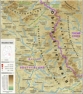
The Upper Palatinate Forest , in Czech Český les (Bohemian Forest), is a north-south running low mountain range along the border between Bavaria and the Czech Republic . Geologically it belongs to the Bohemian Massif , in the north it borders on the Fichtelgebirge or the Steinwald , in the south on the Bavarian Forest .
geography
The Upper Palatinate Forest extends over 100 km between the towns of Waldsassen in the north and Waldmünchen in the south. Its width measures about 30 to 40 km. To the south it goes over into the Cham-Further Senke , the Neumarker Senke , the Neumarker Pass and the Neugedeiner Furche , which separate it from the Bohemian Forest .
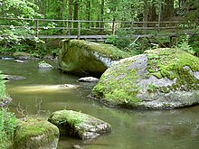
Characteristic for the low mountain range are deep valleys, castles and ruins , wide views, remote churches and chapels and so-called clearing islands . In the Middle Ages , large areas of forest were cut down for the numerous iron hammers and glassworks that stood by the rivers and streams. The clearing that took place at that time is still recognizable after the reforestation that has taken place since then .
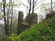
The castles and castle ruins characteristic of the Upper Palatinate Forest were built as fortifications between the 11th and 13th centuries.
Geomorphological classification
- System: Hercynian
- Subsystem: Hercynian Mountains
- Province: Bohemian Massif ( Česká vysočina )
- Subprovince: Šumavská subprovincie (Bohemian Forest Subprovince)
- Area: Českoleská oblast (Upper Palatinate Forest area)
- Main unit: Český les (Upper Palatinate Forest)
- Sub- unit: Čerchovský les , Kateřinská kotlina , Přimdský les , Dyleňský les
geology
Geologically , as part of the Bohemian Massif , it essentially consists of various gneisses with partly intercalated Redwitzites and calcium silicates. Furthermore, there are large granite - intrusive bodies such as the lights Berger or Flossenbürger granite . Serpentinites also occur in the west and north . The southern part of the Upper Palatinate Forest with its polymetamorphic gneisses belongs to the Moldanubic , while the extreme north around Waldsassen already belongs to the Saxothuringic .
The Upper Palatinate Forest was known for its gold deposits , which were repeatedly exhausted in the past. In 2009, Deutsche Rohstoff AG began exploring again .
climate
The climate in the Upper Palatinate Forest is subcontinental or humid continental, the long-term annual mean air temperature for Flossenbürg at 840 m above sea level is 6.2 ° C. The average annual precipitation is 960 l / m² (1998–2011) and the average vegetation period is 128 days (with a daily mean temperature of more than 10 ° C). The annual average temperature for pastures (397 m above sea level), however, is 8.1 ° C, the average annual precipitation is 715 mm with a vegetation period of 160 days.
mountains
The highest elevations in the Upper Palatinate Forest are - sorted according to height (for the mountains in Germany in meters (m) above sea level ; for those in the Czech Republic in metrů nad mořem (m nm; meters above sea level)):
- Čerchov ( Schwarzkopf ; 1042 m), Czech Republic
- Skalka (1005 m), Czech Republic
- Dyleň ( Tillenberg ; 939 m), Czech Republic
- Kreuzfelsen (938 m), Bavaria
- Entenbühl (901 m), Bavaria
- Weingartnerfels (896 m), Bavaria
- Havran ( Großer Rabenberg ; 894 m), Czech Republic
- Signalberg (888 m), Bavaria
- Herštejn ( Hirschstein ; 878 m) Czech Republic
- Reichenstein (874 m), Bavaria
- Lysá hora ( Lissaberg ; 870 m), Czech Republic
- Velký Zvon ( Plattenberg ; 856 m), Czech Republic
- Přimda ( Pfraumberg ; 848 m), Czech Republic
- Frauenstein (835 m), Bavaria
- Schellenberg (829 m), Bavaria
- Stückberg (808.6 m), Bavaria
- Steinberg (802 m), Bavaria
- Great Dürrmaul (801 m), Bavaria
- Fahrberg (801 m), Bavaria
- Velká skála ( Big Rock , 792 m), Czech Republic
- Železný vrch ( Eisenberg , 790 m), Czech Republic
- Buchsberg (789 m), Bavaria
- Iceberg (771 m), Bavaria
- Sulzberg (755 m), Bavaria
- Výšina ( Neubäuhöhe , 708 m), Czech Republic
- Schwarzwihrberg / Schloßberg (706 m), Bavaria
- Geissleite (636 m), Bavaria
- Fischerberg (633 m), Bavaria
- Holy Trinity Mountain (631 m), Bavaria
- Jezevčí vrch ( Dachsberg ; 630), Czech Republic
- Kulm (626 m), Bavaria
- Katzenstein (622 m), Bavaria
- Johannisberg (605 m), Bavaria
Important places
On the Bavarian side:
- Bärnau
- Eslarn
- Falkenberg
- raft
- Flossenbürg
- Leuchtenberg
- Moosbach
- Neualbenreuth
- Neunburg vorm Wald
- Neustadt an der Waldnaab
- Niedermurach
- Pleystein
- Plößberg
- Oberviechtach
- Rötz
- Schönsee
- Tännesberg
- Tirschenreuth
- Vohenstrauss
- Waidhaus
- Waldmünchen
- Waldsassen
- Waldthurn
- Winklarn
On the Czech side:
- Bělá nad Radbuzou (white brine)
- Bor u Tachova (Haid)
- Cheb (Eger)
- Chodová Planá (Cowl Plan )
- Domažlice (dew)
- Horšovský Týn (Bischofteinitz)
- Kladruby u Stříbra (Kladrau)
- Lázně Kynžvart (Königswart Spa)
- Mariánské Lázně (Marienbad)
- Planá u Mariánských Lázní (map)
- Přimda (Pfraumberg)
- Stříbro (bad)
- Tachov (Tachau)
Rivers
Several rivers have their source in the Upper Palatinate Forest:
- the Wondreb
- the Waldnaab
- the raft
- the lousy
- the Radbuza (Radbusa)
- the Úhlavka (Aulowa)
- the Kosový potok (Amselbach)
- the Luhe
- the Pfreimd
- the Zottbach
- the Schwarzach
- the Murach
- the asha
- the Hammerbach (Hamerský potok)
- the Zubřina (Watow)
Castles and castle ruins
see also: List of castles and palaces in Bavaria / RB Upper Palatinate
- Neuhaus Castle
- Trausnitz Castle
- Falkenberg Castle (Upper Palatinate)
- House Murach
- Leuchtenberg castle ruins
- Parkstein castle ruins
- Störnstein ruins
- Schellenberg Castle
- Liebenstein ruins
- Flossenbürg Castle
- Frauenstein Castle near Winklarn
- Reichenstein ruins near Schönsee
- Treswitz Castle
- Schwärzenberg ruins
- Schwarzenburg ruins
- Thannstein Castle
- Waldau Castle
- Wildenau Castle
Nature landmarks
- Muglbach waterfall: in the forest between Neualbenreuth and Mähring
- Wild and romantic Waldnaab valley : between Falkenberg and Windischeschenbach
- Tirschenreuther Teichpfanne : pond area in the triangle Tirschenreuth, Wiesau, Mitterteich
- Teufelsküche : Granite bastions in a brook valley south of Tirschenreuth
- Wolfenstein : single standing, distinctive granite block near Hohenwald
- Doost : mighty granite blocks in the Girnitzbach near Floß
- Schlossberg Flossenburg : with zwiebelschalenartigem granite insightful
- Lerautal: romantic brook valley near Leuchtenberg
- Kulzer Moos: Part of the Prackendorfer Moos moor near Winklarn
- Rose quartz rock : erosion remains of a large pegmatite in the center of Pleystein
- Zottbachtal: romantic Zottbachtal near Pleystein , along this valley leads the Glasschleiferstraße
- Stone wall: rock ridge on the Schwarzwihrberg , on which a hiking trail runs and connects many viewpoints
See also
Web links
- www.oberpfaelzerwald.de - Oberpfälzerwald.de
- www.bocklradweg.de - Railroad cycling and information about the Upper Palatinate Forest
- www.oberpfaelzer-wald.net - Upper Palatinate Forest Adventure Region
Individual evidence
- ^ Harald Elsner: Gold extraction in Germany - history and potential. (PDF) Federal Institute for Geosciences and Natural Resources , February 16, 2009, accessed on May 18, 2012 .
- ↑ https://www.lwf.bayern.de/boden-klima/umweltmonitoring/106056/index.php
- ↑ https://www.dwd.de/DE/wetter/wetterundklima_vorort/bayern/weiden/_node.html
- ↑ https://de.weatherspark.com/y/73259/Durchschnittswetter-in-Weiden-Deutschland-das-ganze-jahr-%C3%BCber


