Jauerling
| Jauerling | ||
|---|---|---|
|
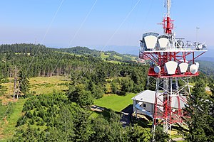
View from the observation tower over the plateau in northeast direction |
||
| height | 960 m above sea level A. | |
| location | Lower Austria , Austria | |
| Mountains | High Waldviertel | |
| Dominance | 15.6 km → Weinsberger Forest | |
| Notch height | 459 m ↓ northwest. Zeining | |
| Coordinates | 48 ° 20 '23 " N , 15 ° 20' 17" E | |
|
|
||
| particularities | Sendeturm jauerling , Aussichtswarte Jauerling | |
The Jauerling is a mountain in the south-eastern Waldviertel in Lower Austria . At 960 m above sea level A. it is the highest point in the Wachau .
Naming
The name originated from the Slavic word Javornik , which means something like "Ahornberg".
topography
The summit region is flat and plateau-like, so that two points rise 960 m above sea level. A. reach, but summit crosses have been set up in other places. A point marked with a summit cross is explicitly named False Summit . The summit region is accessible via Oberndorf with a public road and then in several driveways. At its foot the Danube flows in the east and the Spitzer Bach in the north and west .
On the Jauerling there is a transmission system for VHF, radio relay and TV and a viewing point . The Jahn memorial is located in the western corner of the Jahnwiese, where the sports facilities are located . On the eastern slope there is also a small ski area with floodlights , in which the first World Cup race , a floodlit snowboard parallel slalom, took place on January 13, 2012 .
climate
At the Jauerling there is a transitional climate with continental influence from the east and oceanic influence from the west. The annual mean temperature in the 30-year mean 1971–2000 is 6.5 ° C, the annual precipitation is 729.4 mm. There are around 120 frost days and 50 ice days every year . Due to the altitude, the weather station on the Jauerling is often located above the cold air lakes or the inversion layer . As a result, the nocturnal lows and the hours of sunshine are higher than in lower-lying areas. Every year around 195 cm of snow falls . According to statistics, there are 15 thunderstorms per year, 14 of which occur between April and September. The monthly mean wind speed is hardly subject to fluctuations and is around 9 km / h on an annual average. The prevailing westerly winds are characteristic . The number of summer days is noticeably reduced compared to lower altitudes due to the lower daily warming. About 10 such days occur annually.
|
Average monthly temperatures, precipitation and sunshine hours for Jauerling (952 m)
|
|||||||||||||||||||||||||||||||||||||||||||||||||||||||||||||||||||||||||||||||||||||||||||||||||||||||||||||||||||||||||||||||||||||||||||||||||||||||||||||||||||||||||||||||||||||||||||||||||||||||||||||||||||||||||||||||||
See also
Web links
Individual evidence
- ^ Franz Eppel: The Waldviertel, its works of art, historical forms of life and settlement , Salzburg 1989, p 12f, ISBN 3-900173-01-X
- ↑ NÖN-KW44 / 2011 - supplement "Ski-Extra", page 7

