Bacan Islands
| Bacan Islands | ||
|---|---|---|
| Location of the main island of Bacan | ||
| Waters | Moluccan Sea ( Pacific Ocean ) | |
| archipelago | Moluccas | |
| Geographical location | 0 ° 37 ′ S , 127 ° 31 ′ E | |
|
|
||
| Number of islands | 80 | |
| Main island | Bacan | |
| Total land area | 1900 km² | |
| Residents | 13,000 | |
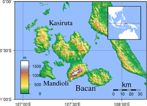
| Topographic map of the Bacan Islands | ||
The Bacan Islands (formerly Batchian Islands ) are an Indonesian group of islands in the Pacific Ocean . The islands belong to the Moluccas and are located in the southern part of the province of Maluku Utara ("North Moluccas"). It is named after the main island of the same name, Bacan .
geography
The Bacan Islands consist of about 80 islands. The main island is Bacan , with a size of 1900 km². It is of volcanic origin and is located about 20 kilometers off the coast of the southern peninsula of Halmahera . The largest settlement is Labuha on the west coast.
The second largest island is Kasiruta in the northwest. to the west is Mandioli (highest elevation: 311 meters), opposite the Bay of Labua on Bacan. The island of Obit lies between the two larger islands . To the north-west of Kasiruta are Latalata (highest elevation: 358 meters) and Muari .
Bacan Island is densely forested. Coconut palms , sago palms and clove trees , which are naturally widespread here, thrive on the islands . The megachile pluto , the largest species of bee in the world, was originally discovered in the Bacan Islands.
Residents
An estimated 13,000 people live on Bacan Island. Most of the inhabitants of the archipelago live on the coasts.
history
At the beginning of the 16th century, the capital of a small empire, whose area of influence extended to the island of Bacan and in the south to the north coast of Seram , was on the island of Kasiruta. The first Portuguese merchant ships landed on Bacan in 1513, and a fortress was built in 1558. The Portuguese fortress was captured by the Dutch East India Company in 1609 as the beginning of Dutch rule over the islands by Vice Admiral Hoen. At that time, the Northern Moluccas had a monopoly on the trade in the coveted cloves. At the end of the 16th century, the Bacan Empire seems to have paid tribute to the Sultanate of Tidore .
During a revolt of the Tidore Prince Nuku against the supremacy of the Dutch on the Moluccas, which lasted from 1780 to 1810, the islands were taken by English traders with his support at the end of the 1790s. After 1816 rule over Indonesia fell back to the Dutch, who in 1889 replaced the island monarch with a local administration appointed by them.
traffic
There are ship connections from Labuha, including to Obi Island in the south and to Ternate in the north.
Individual evidence
- ↑ encyclopedievanzeeland.nl: Apollonius Schotte , accessed on December 2, 2017.


