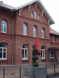
Reken train station
|
Reken train station
Reken municipality
Coordinates: 51 ° 48 ′ 7 ″ N , 7 ° 2 ′ 59 ″ E
|
||
|---|---|---|
| Height : | 80 m | |
| Area : | 1.79 km² | |
| Residents : | 2250 | |
| Population density : | 1,257 inhabitants / km² | |
| Postal code : | 48734 | |
| Area code : | 02864 | |
|
Location of Bahnhof Reken in North Rhine-Westphalia |
||
|
The Reken train station in 2008
|
||
Bahnhof Reken is a district of the municipality of Reken in the western Münsterland in the north-west of North Rhine-Westphalia and belongs to the Borken district .
The place, which arose as a settlement around the train station, is south of Groß Reken . The Boombach flows not far to the northeast and east of the town . South, 0.5 extend ha large protected area (NSG) Hülstenholter Wacholderheide and the 2,6 hectare NSG Hülstener Wacholderheide .
geography
Reken station is located in the Reken mountains , which are part of the Hohe Mark ridge . The Hohe Mark Nature Park forms the southern border of the Münsterland towards the Ruhr area and the lowlands of the Lippe and Emscher . Reken station drains over the Midlicher Mühlenbach (in the west) and the Boombach (in the east) into the Lippe.
| Illerhusen peasantry
(to Reken ) |
Great Reken
(to Reken ) |
Maria Veen
(to Reken ) |
| Kreulkerhok peasantry
(to Reken ) |

|
Hülsten peasantry
(to Reken ) |
| Wessendorf peasantry
(to Reken ) |
Klein Reken
(to Reken ) |
Lavesum
(to Haltern am See ) |
Attractions
In the list of architectural monuments in Reken , one architectural monument is listed for Reken station - the Reken station reception building (Bahnhofstrasse 35). The station building, which was no longer in use, was completely renovated in 2005/2006.
See also
Web links
- The district of Bahnhof Reken on heimatarchiv-reken.de


