Le Coteau – Montchanin railway line
| Coteau-Montchanin | |||||||||||||||||||||||||||||||||||||||||||||||||||||||||||||||||||||||||||||||||||||||||||||||||||||||||||||||||||||||||||||||||||||||||||||||||||||||||||||||||||||||||||||||||||||||||
|---|---|---|---|---|---|---|---|---|---|---|---|---|---|---|---|---|---|---|---|---|---|---|---|---|---|---|---|---|---|---|---|---|---|---|---|---|---|---|---|---|---|---|---|---|---|---|---|---|---|---|---|---|---|---|---|---|---|---|---|---|---|---|---|---|---|---|---|---|---|---|---|---|---|---|---|---|---|---|---|---|---|---|---|---|---|---|---|---|---|---|---|---|---|---|---|---|---|---|---|---|---|---|---|---|---|---|---|---|---|---|---|---|---|---|---|---|---|---|---|---|---|---|---|---|---|---|---|---|---|---|---|---|---|---|---|---|---|---|---|---|---|---|---|---|---|---|---|---|---|---|---|---|---|---|---|---|---|---|---|---|---|---|---|---|---|---|---|---|---|---|---|---|---|---|---|---|---|---|---|---|---|---|---|---|---|
|
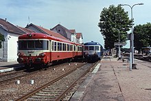
Coteau train station, April 2018
| |||||||||||||||||||||||||||||||||||||||||||||||||||||||||||||||||||||||||||||||||||||||||||||||||||||||||||||||||||||||||||||||||||||||||||||||||||||||||||||||||||||||||||||||||||||||||
| Route number (SNCF) : | 769,000 | ||||||||||||||||||||||||||||||||||||||||||||||||||||||||||||||||||||||||||||||||||||||||||||||||||||||||||||||||||||||||||||||||||||||||||||||||||||||||||||||||||||||||||||||||||||||||
| Route length: | 107.5 km | ||||||||||||||||||||||||||||||||||||||||||||||||||||||||||||||||||||||||||||||||||||||||||||||||||||||||||||||||||||||||||||||||||||||||||||||||||||||||||||||||||||||||||||||||||||||||
| Gauge : | 1435 mm ( standard gauge ) | ||||||||||||||||||||||||||||||||||||||||||||||||||||||||||||||||||||||||||||||||||||||||||||||||||||||||||||||||||||||||||||||||||||||||||||||||||||||||||||||||||||||||||||||||||||||||
| Maximum slope : | 10 ‰ | ||||||||||||||||||||||||||||||||||||||||||||||||||||||||||||||||||||||||||||||||||||||||||||||||||||||||||||||||||||||||||||||||||||||||||||||||||||||||||||||||||||||||||||||||||||||||
| Dual track : | partly yes | ||||||||||||||||||||||||||||||||||||||||||||||||||||||||||||||||||||||||||||||||||||||||||||||||||||||||||||||||||||||||||||||||||||||||||||||||||||||||||||||||||||||||||||||||||||||||
|
|||||||||||||||||||||||||||||||||||||||||||||||||||||||||||||||||||||||||||||||||||||||||||||||||||||||||||||||||||||||||||||||||||||||||||||||||||||||||||||||||||||||||||||||||||||||||
The Coteau – Montchanin railway is a nearly 110 km long, standard-gauge , north-south French railway line, of which only the northern half still exists today and is served by regional trains and freight traffic. The southern section has been de-dedicated since 1995 and was expanded as a cycle path between Pouilly-sous-Charlieu and Paray-le-Monial at the end of 2019.
history
Roanne and its suburb of today, Le Coteau , had been supplied with this new type of infrastructure with the Roanne – Andrézieux railway since 1833 and the railway network in France expanded rapidly.
An original license application for the construction and operation of that line came from the railway company Chemin de fer Grand Central de France , but after its bankruptcy and its resolution 1857 to the much more financially stronger Chemins de fer de Paris à Lyon et à la Méditerranée fell . The route between Roanne and Paray-le-Monial was controversial for a long time; should the route from Saint-Étienne be on the right or left bank of the Loire ? After several hearings, the Minister of Transport Eugène Caillaux decided on December 16, 1874 for the alignment on the right bank of the Loire. The line was finally opened on July 3, 1875 after the northern - undisputed - section Paray-le-Monial – Montchanin was opened to traffic on June 19, 1857.
Route description
This railway line did not require any special engineering structures for its construction. The most important single structure, the Loire Bridge between Roanne and Le Coteau, no longer belonged to this line, but to the Moret-Veneux-les-Sablons-Lyon-Perrache railway line . The profile is very flat. In the southern section to Paray-le-Monial, the route leads almost continuously downhill with a maximum gradient of 8 ‰ . The train stations are relatively far apart in the sparsely populated landscape. There was and is hardly any industry, except in Roanne, Paray-le-Monial and the Montceau-les-Mines / Montchanin region .
Individual evidence
- ↑ SNCF Region du Sud-Est. Carnet de profils et schémas , 1959. Pages 37 and 87
- ↑ a b Rapport du Préfet , Conseil Géneral, Département de Saône-et-Loire, April 1875
- ^ Ligne Le Coteau - Montchanin , on Fandom, infrastructure ferroviaire française


