Bajamar (La Laguna)
| San Cristóbal de La Laguna municipality: Bajamar | ||
|---|---|---|
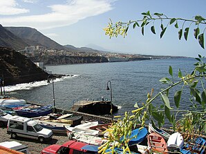
 View of Bajamar from Punta del Hidalgo
|
||
| coat of arms | Map of the Canary Islands | |
 Help on coat of arms |
|
|
| Basic data | ||
| Autonomous Community : | Canary Islands | |
| Province : | Santa Cruz de Tenerife | |
| Island: | Tenerife | |
| Coordinates | 28 ° 33 ′ N , 16 ° 21 ′ W | |
| Residents : | 2,219 (2011) INE | |
| Postal code : | 38250 | |
| Area code: | 38023000200 | |
Bajamar is a district of the municipality of San Cristóbal de La Laguna in the north of the island of Tenerife . According to the Instituto Nacional de Estadística , Bajamar had 2,219 inhabitants on January 1, 2011.
Bajamar is located on the western edge of the Anaga Mountains on the TF-13 provincial road. The bus routes 105 and 50 connect it every half hour with La Laguna and in rush hour also directly with Santa Cruz .
Residents
| 2000 | 2001 | 2002 | 2003 | 2004 | 2005 | 2006 | 2007 | 2008 | 2009 | 2010 | 2011 |
|---|---|---|---|---|---|---|---|---|---|---|---|
| 1,412 | 1,546 | 1,615 | 1,673 | 1,681 | 1,826 | 1,882 | 1,878 | 1,992 | 2,106 | 2.147 | 2,219 |
Attractions
- Sea water swimming pool (Piscinas naturales) and pier with beacon .
- San Juan Bautista pilgrimage chapel from 1628 in the old town center.
Individual evidence
- ↑ a b Population statistics for Bajamar of the Instituto Nacional de Estadística español (INE). Accessed on December 8, 2012 (English / Spanish).
- ↑ Timetable Titsa line 105. Accessed October 31, 2013 .
- ↑ Timetable Titsa line 50.Retrieved on October 31, 2013 .

