
Bangabandhu Bridge
Coordinates: 24 ° 24 ′ 0 ″ N , 89 ° 46 ′ 41 ″ E
| Bangabandhu Bridge Jamuna Multipurpose Bridge বঙ্গবন্ধু সেতু |
||
|---|---|---|
 |
||
| use | Road and rail bridge | |
| Crossing of | Jamuna | |
| place | about 7 km south of the city of Sirajganj in Bangladesh | |
| Entertained by | Bangladesh Bridge Authority | |
| construction | Prestressed concrete - box girder bridge | |
| overall length | 4.8 km | |
| width | 18.5 m (deck girder) | |
| Longest span | 100 m | |
| Pillar strength | 2.5 to 3.15 m | |
| building-costs | approx. US $ 753.7 million | |
| start of building | 1994 | |
| completion | 1998 | |
| opening | June 23, 1998 | |
| toll |
Tariffs 2017: Motorbike: 40 Taka Motor vehicle: 500 Taka small bus: 650 Taka large bus: 900 Taka small truck: 850 Taka medium truck: 1100 Taka heavy truck: 1400 Taka |
|
| location | ||
|
||

The Bangabandhu Bridge ( Bengali বঙ্গবন্ধু সেতু Baṅgabandhu sētu , often also Bengali যমুনা বহুমুখী সেতু Yomunā bahumukhī sētu , Jamuna Multi-purpose Bridge , "Jamuna multi-purpose bridge ") is a 4.8 kilometer long railway and road bridge over the Jamuna in Bangladesh . It opened in 1998. The name of the bridge recalls the honorary title of the first Prime Minister of independent Bangladesh, Sheikh Mujibur Rahman .
Background and story
The natural landscape and the habitat of Bangladesh are essentially determined by two large rivers that flow through the country. On the one hand the lower reaches of the Ganges , which in Bangladesh bears the name Padma (and in the end section Meghna ), on the other hand the Jamuna, one of the end arms of the Brahmaputra , which flows into the Padma. On the one hand, these large rivers, which have often changed their course in the past, form important traffic arteries; on the other hand, they are also major obstacles to national rail and road traffic. Bridge structures are therefore of central importance for the transport infrastructure of Bangladesh.
Although the construction of railways in Bengal began as early as the 19th century during British colonial rule , there was no railway or road bridge over the Jamuna for a long time. As a result, the railway networks on both sides of the Jamuna developed relatively independently of one another. To the west of the river was the Indian broad gauge and east of it the meter gauge . Connections of the two railway networks and road networks had to be made on the way of car ferries and rail ferries . The most important of these compounds on the Jamuna before the opening of Bangabandhu bridge were ferries on Jamuna underflow between Nagarbari ( 23 ° 57 ' N , 89 ° 39' O ) and Aricha ( 23 ° 51 ' N , 89 ° 47' O ), and to the north between Sirajganj ( 24 ° 28 ' N , 89 ° 43' O ) and Bhuapur ( 24 ° 28 ' N , 89 ° 52' O ). However, these ferry connections reached their limits by the 1980s at the latest. Waiting times of 30 to 40 hours for the next available ferry have been the order of the day for trucks since the 1980s. The daily traffic on these two crossings amounted to a total of 271 buses, 140 light trucks and 770 trucks in 1993.
Planning and execution of the bridge construction


The first plans to build a bridge over the Jamuna to better connect East and West Bangladesh were made in the 1960s during the times of East Pakistan , before the independence of Bangladesh. However, due to the lack of resources and the political instability, more concrete planning began only in the 1980s. In 1985 a separate authority was established for this purpose, the Jamuna Multipurpose Bridge Authority , which later also took over the organization of the construction.
A total of 10 different locations for the construction of the bridge were included in the shortlist. After a thorough examination, the decision was made for a location about 7 kilometers south of the city of Sirajganj . At this point the Jamuna was up to 14 kilometers wide during high tide. At low tide, the river width could decrease to up to 5 kilometers. In connection with the bridge construction, 16 and 14 kilometers of roads had to be built to the east and west of it. To the north and south of the bridge, the banks of the Jamuna were paved for 2.2 kilometers each, and measures to prevent flooding were taken.
When building the bridge piers, for reasons of stability, it was decided not to use a traditional caisson construction method, but to use steel pipes that were driven into the ground by means of a hydraulic MHU 1700T hammer from Menck GmbH . In doing so, it was possible to fall back on experience in the construction of offshore platforms in the previous two decades. The steel tubes were manufactured in Ulsan ( South Korea ) in individual segments that could be plugged into one another and then welded and brought to the construction site by ship. The time of the Jamuna flood had to be used for the delivery. After the steel tube had been driven deep enough into the ground, the uppermost part (which was mostly damaged by the hammer) was cut off and the tube was filled with concrete. A prefabricated concrete "cap" weighing about 300 tons was placed on each of two or three pillars, which are slightly offset from one another. All 121 piers could be driven into the ground as planned between October 1995 and June 1996, during the flood period. The other bridge structures were assembled from pre-stressed concrete parts and driven forward from the bridge piers using the cantilever method.
Cost and schedule
The total cost of the project was estimated at $ 696 million prior to commencement. Of this, around 220 million were accounted for by the actual bridge construction and 244 million for river fortification measures and other hydraulic engineering measures. The construction of the access roads was estimated at US $ 52 million. In terms of funding, the Asian Development Bank , the International Development Organization (IDA) and the Japanese Development Aid Overseas Economic Cooperation Fund (OECF) should each provide US $ 200 million . The Bangladeshi government was to contribute a further US $ 96 million. An estimate in June 2000 showed that actual costs were US $ 753.7 million, an 8.3% overrun of the original budget. The original schedule was for the bridge to be completed by November 1997. In fact, this goal was not achieved until 7 months later in June 1998. However, the deadline for the release for traffic could be kept as planned.
The bridge was opened to traffic on June 23, 1998 in a solemn ceremony by then Prime Minister Hasina Wajed and named "Bangabandu Bridge" - in honor of Mujibur Rahman, the first Prime Minister of Bangladesh and father of Hasina Wajed.
Technical data and dimensions
The actual bridge is 4.8 kilometers long. There is a 128 meter long viaduct at both ends of the bridge , which ensures the connection to the access roads. Four lanes of road, a pedestrian path and a single-lane railway line run along the bridge. The deck is 18.5 meters wide. In addition, the bridge carries a 230 kV high voltage line, a 760 mm gas line and telecommunication cables. The railway line was originally built in meter gauge , but later expanded to a three- rail track ( dual gauge ) so that it can also be used by trains in broad gauge.
The bridge rests on 50 girders. 21 girders were founded on 3 steel pillars each and 29 on 2 steel pillars each. The thickness of the steel jacket was 40-60 mm, the average length of the steel pillars is 83 meters and the outer diameter is 2.5 and 3.15 meters. The bridge girders were erected at intervals of 100 m.
Development since 1998
| Fiscal year | vehicles | Income (Mio Taka ) |
|---|---|---|
| 1997-98 | 27,651 | 9.9 |
| 1998-99 | 930,659 | 612.7 |
| 1999-00 | 892.149 | 669.4 |
| 2000-01 | 1.110.070 | 828.4 |
| 2001-02 | 1,222,919 | 935.8 |
| 2002-03 | 1,375,009 | 1087.2 |
| 2003-04 | 1.632.205 | 1310.8 |
| 2004-05 | 1,876,363 | 1520.0 |
| 2005-06 | 1,987,984 | 1579.7 |
| 2006-07 | 2,172,463 | 1737.6 |
| 2007-08 | 2,539,421 | 2019.6 |
| 2008-09 | 2,751,849 | 2144.2 |
| 2009-10 | 3,157,372 | 2429.9 |
| 2010-11 | 3,564,713 | 2691.0 |
| 2011-12 | 3,698,743 | 3062.3 |
| 2012–13 | 3,887,158 | 3279.8 |
| 2013-14 | 3,926,990 | 3253.8 |
| 2014–15 | 4,207,075 | 3511.4 |
| 2015–16 | 4,807,915 | 4048.8 |
| 2016–17 | 5,383,119 | 4865.2 |
| 2017-18 | 5,532,536 | 5438.0 |
| 2018–19 | 5753.4 |
Before the bridge was built, traffic forecasts were based on the assumption that total traffic would grow by 5 percent annually from 1998 to 2025 until the bridge's final capacity was reached in 2025.
The average annual increase in traffic volume from 1998 to 2018 was around 10% and toll revenues rose by 12.2% annually. The forecasts were thus clearly exceeded. Repeatedly, however, allegations of corruption have been raised against the direct operating companies, so that the real "revenues" may be even higher.
In February 2019, the Bangladeshi government announced that the bridge had so far generated 50 billion Taka in toll revenue. This would be offset by construction costs of 37.5 billion Taka. The loans taken out to build the bridge would not be paid off until 2034. According to official information, the duration of the loan repayments had been extended due to unfavorable exchange rates.
In 2016, crossing the bridge in a simple car cost 500 Taka (just under 6 EUR). A heavy truck had to pay 1,400 taka (about 16 EUR). The bridge tariff has been increased several times, for example by 14% in 2011. In March 2017, the government announced another increase by an average of around 20%.
The 2001 parliamentary elections were won by the Bangladesh Nationalist Party (BNP) under Khaleda Zia , who subsequently became Prime Minister. Under the BNP government, the bridge was renamed the Jamuna Multipurpose Bridge . When the Awami League under Hasina Wajid won again after the parliamentary elections in 2008 , the bridge officially got its old name again in 2009. Both names are in use.
In 2011–2013 extensive repairs were necessary because of cracks that had occurred, which cost 2.7 billion (270.45 crore ) Taka . In 2014 cracks were found again, the repair of which was estimated at 1.15 billion Taka.
Between 2004 and 2006 there were around 80 accidents annually on the access roads to the bridge and on the bridge itself, resulting in a total of 71 fatalities. The high number of road deaths is not atypical for road traffic in Bangladesh. 96% of the deaths occurred on the access roads and only 4% directly on the bridge. Analyzes showed that the accidents are particularly concentrated on certain points. The roundabouts in front of the bridges were identified as particularly prone to accidents. For the most part, excessive speed was given as a (co-) cause. The maximum speed on the access roads is 80 km / h, on the bridge itself 40 km / h.
On January 22, 2019, the Bangladeshi Railway Minister announced that the government intended to build a railway bridge parallel to the Bangabandhu Bridge.
- Different views of the bridge

View from the shore

Toll booth

Road traffic on the bridge

On the bridge (view from the train compartment)
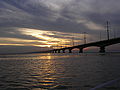
Bridge in the late evening

_Jamuna_Bridge.JPG)


See also
literature
- Joe M. Bar, Abdul Farooq, Steve Guest: Foundations for Major Bridges - Design and Construction . IABSE Colloquium, New Delhi, India - 22.-24. February 1999 PDF
- jamuna setu in Bangladesh fumigates setu , video of a journey to and crossing the bridge by bus (YouTube)
Web links
Individual evidence
- ↑ Welcome to Bangladesh Bridge Authority. Bangladesh Bridge Authority, accessed July 9, 2016 .
- ↑ a b Great Rate Bangabandhu Bridge. Bangladesh Bridge Authority, accessed March 26, 2020 .
- ↑ a b Jamuna bridge and dual-gauging unite the BR network. Railway Gazette, June 1, 2002, accessed July 9, 2016 .
- ↑ a b c d Jenkins GP, Shukla GP: Linking East and West Bangladesh: the Jamuna Bridge Project. The Canadian Journal of Program Evaluation; 1997, pp. 121-145. ISSN 0834-1516 PDF
- ↑ Joe M. Barr, Abdul Farooq, Steve Guest: Foundations for Major Bridges - Design and Construction . IABSE Colloquium, New Delhi, India - 22.-24. February 1999 PDF doi: 10.5169 / seals-60767
- ^ Jamuna Multipurpose Bridge Project. (PDF) March 2001, accessed on July 6, 2016 (English).
- ↑ a b Bangabandhu Bridge gets back its old name. The Daily Star, January 20, 2009, accessed July 9, 2016 .
- ^ Bangabandhu Multipurpose Bridge: About Bangabandhu Bridge. (No longer available online.) Bangladesh Bridge Authority, archived from the original on July 9, 2016 ; accessed on July 8, 2016 .
- ↑ Jamuna Bridge. Menck, accessed July 8, 2016 .
- ↑ Comparative Statement of Monthly Traffic Bangabandhu Bridge. Bangladesh Bridge Authority, accessed February 3, 2018 .
- ↑ a b The total amount of toll collected at a glance. Bangladesh Bridge Authority, accessed March 8, 2019 .
- ^ Traffic of Bridges. Bangladesh Bridge Authority, accessed March 8, 2019 .
- ↑ M. Abul Kalam Azad: Toll money gobbled up. The Daily Star, April 20, 2013, accessed on March 3, 2018 .
- ↑ Bangabandhu Bridge's construction cost recovered by toll collection. bdnews24.com, February 4, 2019, accessed March 8, 2019 .
- ↑ Asif Showkat Kallol: Bangabandhu Bridge tolls hiked. Dhaka Tribune, March 30, 2017, accessed March 3, 2018 .
- ↑ Bangabandhu Bridge develops fresh cracks. New Age, December 10, 2014, accessed July 9, 2016 .
- ↑ Md. Mazharul Hoque, SM Sohel Mahmud, Kazi Md. Saifun Newaz, Shahnewaz Hasanat-E-Rabbi: Road safety hazards at Jamuna Multipurpose Bridge (JMB) site: implications for bridge design. 3rd ARRB Conference - Research Partnering with Practitioners, Adelaide, Australia, 2008. PDF ( Memento from April 12, 2015 in the Internet Archive )
- ^ Govt to construct railway bridge beside Bangabandhu bridge. The Daily Star, January 22, 2019, accessed March 8, 2019 .