Barreiras
| Município de Barreiras "A Capital do Oeste Baiano", "O Coração do Oeste Baiano", "Capital da Soja"
Barreiras
|
|||
|---|---|---|---|
|
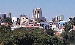
View of Barreiras
|
|||
|
|
|||
| Coordinates | 12 ° 9 ′ S , 44 ° 59 ′ W | ||
 Location of Barreiras in the state of Bahia Location of Barreiras in the state of Bahia
|
|||
| Symbols | |||
|
|||
| founding | 6th April 1891 (age 129) | ||
| Basic data | |||
| Country | Brazil | ||
| State | Bahia | ||
| ISO 3166-2 | BR-BA | ||
| Mesoregion | Extremo Oeste Baiano (1989-2017) | ||
| Microregion | Barreiras (1989-2017) | ||
| structure | 53 Bairros (urban), 23 settlements (rural) | ||
| height | 452 m | ||
| climate | Aw, tropical | ||
| surface | 7,861.8 km² | ||
| Residents | 137,427 (2010) | ||
| density | 17.5 Ew. / km² | ||
| estimate | 155,439 (July 1, 2019) | ||
| Parish code | IBGE : 2903201 | ||
| Post Code | 47.800-000 to 47.814-552 | ||
| Time zone | UTC −3 | ||
| Website |
barreiras.ba camaradebarreiras.ba (Brazilian Portuguese) |
||
| politics | |||
| City Prefect | Zito Barbosa (2017-2020) | ||
| Political party | DEM | ||
| economy | |||
| GDP | 3,716,479 thousand R $ 24,146 R $ per person (2015) |
||
| HDI | 0.721 (2010) | ||
|
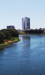
Bend of the Rio Grande within the urban area
|
|||
Barreiras , officially Portuguese Município de Barreiras , is a Brazilian city in the state of Bahia . In 2019, the population was estimated to be 155,439 in an area about ten times the size of the state of Hamburg. The distance to the federal capital Brasília is 648 km and is closer than the state capital Salvador, 863 km away .
Surrounding places are Luís Eduardo Magalhães , São Desidério , Cristópolis , Angical , Riachão das Neves , Formosa do Rio Preto and in the state of Tocantins the places Novo Jardim and Ponte Alta do Bom Jesus .
history
The territory was the traditional settlement area of various Indian tribes belonging to the Macro-Ge language family . In the Empire of Brazil it belonged first to Pernambuco, from 1827 to the province of Bahia . Around 1880 there was an accumulation of around 20 simple huts, the people in the extensive area were combined in a parish (freguesia) in 1881 and added to the municipality known under its current name as Angical . After the founding of the federal state, several places were emancipated, including the Vila de Barreiras and Angical by the Lei Estadual No. 237 of April 6, 1891 . The place received the right to self-administration as a municipality through state law No. 449 of May 19, 1902. At that time, around 2000 people lived in 630 dwellings in Barreiras.
City administration
City prefect (executive) has been Zito Barbosa of the Democratas (DEM) for the 2017-2020 term since the local elections in 2016 . The legislature rests with a city council (Câmara Municipal) made up of 19 city councilors (vereadores).
City structure
The city is divided into 53 bairros in and around the urban core; in rural areas there are another 23 settlements that belong to Barreiras.
Population development
Source: IBGE (figure for 2019 is only an estimate)

climate
The climate is tropical, according to the Köppen-Geiger Aw classification.
| Jan | Feb | Mar | Apr | May | Jun | Jul | Aug | Sep | Oct | Nov | Dec | |||
| Temperature ( ° C ) | 24.7 | 24.7 | 24.5 | 24.4 | 23.4 | 22nd | 21.9 | 23.6 | 25.9 | 26.4 | 25.3 | 24.6 | O | 24.3 |
| Precipitation ( mm ) | 205.4 | 172.4 | 150.5 | 91.4 | 23.1 | 2.5 | 1.2 | 1.5 | 20.1 | 93.6 | 192.9 | 185.4 | Σ | 1140.1 |
education
In 1991 the illiteracy rate was 34.7%, which had already fallen to 13.7% in the 2010 census.
| Illiteracy rate | ||||
|---|---|---|---|---|
| year | percent | |||
| 1991 | 34.7 | |||
| 2000 | 20.7 | |||
| 2010 | 13.7 | |||
literature
- Barreiras. In: Enciclopédia dos municípios brasileiros. IBGE, Rio de Janeiro 1958, Volume 20, pp. 65-69.
Web links
- City Prefecture website , Prefeitura Municipal (Brazilian Portuguese)
- City Council website , Câmara Municipal (Brazilian Portuguese)
Individual evidence
- ↑ a b c IBGE : Barreiras: Panorama. Retrieved September 18, 2019 (Brazilian Portuguese).
- ↑ IBGE: Cidades @ Bahia: Barreiras - Histórico. Retrieved September 28, 2018 (Brazilian Portuguese).
- ↑ Clima: Barreiras , climate-data-org.
- ^ Atlas do Desenvolvimento Humano do Brasil: Barreiras (BA). Retrieved July 2, 2017 (Portuguese).


