
Batha region
| Batha | |
|---|---|
  |
|
| Basic data | |
| Country | Chad |
| Capital | Ati |
| surface | 88,800 km² |
| Residents | 490,000 (calculation 2009) |
| density | 5.5 inhabitants per km² |
| ISO 3166-2 | TD-BA |
Coordinates: 13 ° 12 ' N , 18 ° 18' E
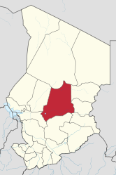
Batha is a region of Chad and corresponds to the former prefecture of the same name. Their capital is Ati . The region had 488,458 inhabitants at the 2009 census.
geography
Batha is located in the center of the country and covers an area of 88,800 km². The region lies in the Sahel zone . In the south-west of the region lies Fitri Lake , one of the few Sahel freshwater lakes in the Chad Basin . One of the largest nature reserves in Africa, the Ouadi Rimé – Ouadi Achim nature reserve , covers an area of 77,950 km² in the north and east of the .
Another town besides Ati is Oum Hadjer .
Breakdown
Batha is divided into three departments ( départements ):
| department | main place | Sub-prefectures |
|---|---|---|
| Batha Est | Oum Hadjer | Am Sack, Assinet, Haraze Djombo Kibit, Oum Hadjer |
| Batha Ouest | Ati | Ati, Djedaa, Koundjourou |
| Fitri | Yao | At Djamena, Yao |
history
In 2019, Mahamat Abdoulaye Senoussi was appointed governor of Batha. Due to illness, however, he could no longer take up the post.
population
Ethnic groups in Batha are Chadian Arabs, Bilala , Kouka , Massalat ( Masalit ) and Mesmédjé .
swell
- ↑ INSEED Chad DEUXIEME - RECENSEMENT GENERAL DE LA POPULATION ET DE L'HABITAT - (RGPH2, 2009) - March 2012 ( Memento of the original from September 24, 2015 in the Internet Archive ) Info: The archive link has been inserted automatically and has not yet been checked. Please check the original and archive link according to the instructions and then remove this notice. , Tables
Barh El Gazel |
Batha |
Borkou |
Chari-Baguirmi |
Ennedi
(divided into Ennedi-Est
and Ennedi-Ouest since 2012 ) |
Guéra |
Hadjer Lamis |
Kanem |
Lac |
Logone Occidental |
Logone Oriental |
Mandoul |
Mayo Kebbi Est |
Mayo-Kebbi Ouest |
Moyen-Chari |
Salamat |
Sila |
Tandjilé |
Tibesti |
Wadai |
Wadi Fira
and Ville de N'Djamena