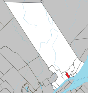
Beaupré (Québec)
| Beaupré | ||
|---|---|---|
| Location in Quebec | ||
|
|
||
| State : |
|
|
| Province : | Quebec | |
| Administrative region : | Capitale-Nationale | |
| MRC or equivalent : | La Cote-de-Beaupré | |
| Coordinates : | 47 ° 3 ′ N , 70 ° 54 ′ W | |
| Height : | 20 m | |
| Area : | 22.66 km² | |
| Residents : | 3439 (as of 2011) | |
| Population density : | 151.8 inhabitants / km² | |
| Time zone : | Eastern Time ( UTC − 5 ) | |
| Municipality number: | 21025 | |
| Postal code : | G0A | |
| Area code : | +1 418 | |
| Mayor : | Michel Paré | |
| Website : | www.villedebeaupre.com | |
 Located in the MRC La Côte-de-Beaupré |
||
Beaupré is a city in the south of the Canadian province of Québec . It is located in the administrative region Capitale-Nationale , about 35 km northwest of the provincial capital Québec . Beaupré belongs to the regional county municipality (municipalité régionale du comté) La Côte-de-Beaupré , has an area of 22.66 km² and has 3,439 inhabitants (2011).
geography
Beaupré is located on the north bank of the St. Lawrence River , at the foot of the Laurentine Mountains . East of the city center is the mouth of the Rivière Sainte-Anne . This tributary flows in a north-south direction through a gorge, the Canyon Sainte-Anne . There the water pours over a 74 meter high waterfall. To the west of the gorge and north of the city rises the 803 meter high Mont Sainte-Anne .
Neighboring municipalities are Sainte-Anne-de-Beaupré in the west, Saint-Ferréol-les-Neiges in the northeast, Saint-Joachim in the east and Saint-François-de-l'Île-d'Orléans in the south.
history
Beaupré was one of the first places to be settled in New France . When Breton sailors landed here in the 17th century, they were supposed to be Oh, le beau pré! (“Oh, the beautiful willow!”). The name was officially used for the first time in 1636 when the Seigneurie Beaupré was founded. The economic upturn began in 1890 with the opening of the Chemin de fer Charlevoix railway line , reinforced by the tourist development of Mont Saint-Anne from the 1960s. The municipality of Notre-Dame-du-Rosaire was founded in 1928, but only one year later it changed its name to Beaupré. Finally, it received city status in 1962. Since 2002 Beaupré has been part of the Communauté métropolitaine de Québec association .
population
According to the 2011 census, Beaupré had 3,439 inhabitants, which corresponds to a population density of 151.8 inh / km². 98.1% of the population stated French as their main language, the share of English was 0.9%. 0.3% said they were bilingual (French and English), other languages and multiple answers accounted for 0.7%. Only French spoke 71.9%. In 2001, 94.1% of the population were Roman Catholic , 1.3% Protestant and 4.0% non-denominational.
Economy and Transport
In addition to industry, tourism is also of great importance. The extensive winter sports area on Mont Sainte-Anne , the largest of its kind in eastern Canada, contributes to this. This mountain is also a popular destination in summer (especially for mountain bikers and hikers). Mountain bike world championships have been held here twice (1998 and 2010).
Beaupré can be reached via route 138 . This supraregional main road runs from the city of Québec parallel to the north bank of the St. Lawrence River for several hundred kilometers to the Côte-Nord region . The railway line between Québec and La Malbaie is used for freight traffic and is used by some tourist passenger trains.
Web links
- Official website of Beaupré (French)
Individual evidence
- ↑ Beaupré. Commission de toponymie du Québec, accessed April 1, 2014 (French).
- ↑ Historique. City of Beaupré, accessed April 1, 2014 (French).
- ↑ Population profile of the municipality of Beaupré. In: 2011 Census. Statistics Canada , 2011, accessed April 1, 2014 (French).
- ↑ Population profile of the municipality of Beaupré. In: 2001 Census. Statistics Canada , 2001, accessed April 1, 2014 (French).
