
Bekölce
| Bekölce | |||||
|
|||||
| Basic data | |||||
|---|---|---|---|---|---|
| State : | Hungary | ||||
| Region : | Northern Hungary | ||||
| County : | Heves | ||||
| Small area until December 31, 2012 : | Bélapátfalva | ||||
| District since 1.1.2013 : | Bélapátfalva | ||||
| Coordinates : | 48 ° 5 ' N , 20 ° 16' E | ||||
| Area : | 13.77 km² | ||||
| Residents : | 647 (Jan. 1, 2011) | ||||
| Population density : | 47 inhabitants per km² | ||||
| Telephone code : | (+36) 36 | ||||
| Postal code : | 3343 | ||||
| KSH kódja: | 04400 | ||||
| Structure and administration (as of 2020) | |||||
| Community type : | local community | ||||
| Mayoress : | Ágnes Gálné Mátrai (independent) | ||||
| Postal address : | Béke út 43 3343 Bekölce |
||||
| Website : | |||||
| (Source: A Magyar Köztársaság helységnévkönyve 2011. január 1st at Központi statisztikai hivatal ) | |||||


Bekölce is a Hungarian community in the county Bélapátfalva in Heves county .
Geographical location
Bekölce is a good six kilometers northwest of the district town of Bélapátfalva . Neighboring communities are Egercsehi in the south and Balaton in the northeast. The highest point is the 457 meter high Magas hegy south of the municipality.
Attractions
- Kisboldogasszony Roman Catholic Church , built in 1735

View of the Roman Catholic Church of Kisboldogasszony
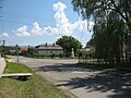
Town center
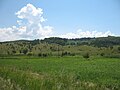
Landscape near Bekölce


Infrastructure
There is a kindergarten, library, family doctor service, pharmacy, post office, cooperative shop, inn, mayor's office and a church in the village. About half of the community area is dominated by beech and oak . Wooded areas and grassy slopes alternate, providing a habitat for large game .
traffic
The road No. 2510 runs through Bekölce, from which the secondary road No. 25105 branches off in a westerly direction and leads to the main road No. 25 . The nearest train station is in Bélapátfalva.
Individual evidence
- ↑ Helyi önkormányzati választások 2019 - Bekölce (Heves megye). Nemzeti Választási Iroda, October 13, 2019, accessed August 1, 2020 (Hungarian).
Web links
- Official website ( Hungarian )
- Bekölce near Magyarország helységnévtára (Hungarian)