Beke (lip)
| Beke | ||
|
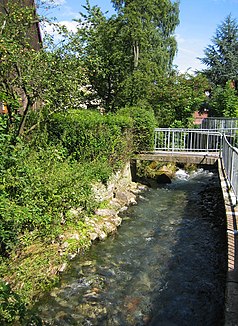
The Beke in Altenbeken |
||
| Data | ||
| Water code | DE : 27816 | |
| location | North Rhine-Westphalia , Germany | |
| River system | Rhine | |
| Drain over | Lippe → Rhine → North Sea | |
| source | At Buke 51 ° 44 ′ 13 ″ N , 8 ° 57 ′ 11 ″ E |
|
| Source height | 317 m above sea level NN | |
| muzzle | At Marienloh in the Lippe coordinates: 51 ° 45 ′ 47 " N , 8 ° 46 ′ 20" E 51 ° 45 ′ 47 " N , 8 ° 46 ′ 20" E |
|
| Mouth height | 120 m above sea level NN | |
| Height difference | 197 m | |
| Bottom slope | 11 ‰ | |
| length | 17.6 km | |
| Catchment area | 49.921 km² | |
| Left tributaries | Silberbeke | |
| Right tributaries | Sagebach , Durbeke | |
| Big cities | Paderborn | |
| Communities | Altenbeken | |
The Beke is a 17.6 kilometer long orographically left or eastern tributary of the Lippe in North Rhine-Westphalia , Germany .
geography
The Beke ( Low German for "Bach") rises in the Altenbeken district of Buke at an altitude of 317 m above sea level. NN . Flowing northwards to Altenbeken, it turns its course to the west here. In the vicinity of the entrance to Altenbeken, the Beke first flows into the water of the Apuhl, then the stream from the Max-und-Moritz-Quelle, the watercourse from the " Bollerborn " and the Sagebach from the north flow to it . About two kilometers west of the Altenbeken Viaduct , the Beke takes on the temporarily flowing Durbeke from the right, which rises about one kilometer north of Kempen on the Rhine-Weser watershed . About one kilometer east of Neuenbeken , the Beke finally takes up the Silberbeke from the Dune Valley, a typical dry valley , from the left, which, however, only very rarely and only after prolonged heavy rain or after the snow has melted, water. In the further course the Beke does not take in any more streams and flows further in a predominantly westerly direction, through the Paderborn districts Neuenbeken and Marienloh , before it flows into the Lippe.
Water flow
In summer, large parts of the Beke are usually dry. The brook seeps away from about one kilometer above Neuenbeken in the karst subsoil, so that until before Marienloh it temporarily has no water. From there the Beke runs through a small spring at least as a small trickle all year round up to its confluence with the Lippe. In winter or after heavy rainfall, the stream carries water along its entire length. When the snow melts or when it rains, the water level of the Beke is sometimes so high that you can go canoeing.
Individual evidence
- ↑ a b German basic map 1: 5,000
- ↑ a b Topographical Information Management, Cologne District Government, Department GEObasis NRW
