
Belchenflue
| Belchenflue | ||
|---|---|---|
 Belchenflue |
||
| height | 1099 m above sea level M. | |
| location | 7 km west of Olten | |
| Mountains | Swiss Jura | |
| Coordinates | 628 096 / 245837 | |
|
||
| rock | Oolithic limestone | |
| particularities | Fortification in the First World War | |

The Belchenflue , called Bölchen by the locals and also called the Swiss Belchen to distinguish it from the mountain peaks of the same name in Germany and France , is a prominent mountain peak in the Swiss Jura . He is 1099 m above sea level. M. high and is about 7 km west of Olten . The border between the cantons of Basel-Landschaft and Solothurn runs over the rocky summit .
geology
The Belchenflue is located in a geologically complex section of the eastern Jura. The limestone and marl layers deposited in a tropical flat sea during the Jurassic period were strongly compressed during the folding of the Jura Mountains in the late Miocene and Pliocene , partly broken up into scales, pushed one on top of the other and placed steeply. The rock summit consists of the hard oolithic limestone of the main roe stone , which was deposited in the middle Jurassic period ( Dogger ). This competent rock layer was carved out by increased erosion of the surrounding softer rocks .
geography
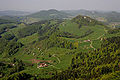
The Belchenflue is limited in the north by the Eptingen basin. In the south, several ridges running parallel with intervening valleys and Ausräumungskesseln before the terrain steeply to the Swiss plateau slopes down. The Belchenflue is characterized by a rock face that falls to the north and is up to 80 m high; The mountain also drops steeply towards the south, but only shows rocks in the summit area. Only a few hundred meters west of the Belchenflue is the wooded Ruchen , which at 1123 m above sea level. M. is a bit higher, but far less distinctive than the Fluh.
The Belchenflue is part of the main Jura chain between north-western Switzerland and the Swiss Plateau. It forms the watershed between the Aare in the south and the Ergolz in the north, both left tributaries of the Rhine . To the east, the chain continues over the Challhöchi and the Ifleterberg to the lower Hauenstein pass . Towards the west, the Dürstelberg descends to the Upper Hauenstein near Langenbruck .
reachability
From the Chilchzimmersattel between Eptingen and Langenbruck , the Belchenflue can be easily reached via a road. A varied footpath leads from Allerheiligenberg near Hägendorf to the top of the mountain. The last section of the path to the summit is a staircase carved out of the rock that is secured with railings. The mountain is a popular vantage point with a clear view in all directions except to the west. On a clear day there is a beautiful panorama of the Alps , the Black Forest and the Vosges .
history
At the time of the First World War , the Belchenflue was an important observation post for the Hauenstein Fortification , a fortress system in the Jura whose aim was to protect the Olten junction. To the east of the Belchenflue, the A2 motorway crosses under the Jura chain in the 3.18 km long Belchen tunnel . From the top of the mountain you can see the motorway sections in the north and in the south as far as the tunnel portals.
Belchen triangle
The mountain name originally comes from the Celtic language and goes back to the sun god Belenus . The Belchenflue is one of the marking points of the seasonal sun visors in the Belchen triangle and in the Belchen system , the starting point of which is the Alsatian Belchen (Ballon d'Alsace) in the Vosges. At the time of the winter solstice, the sun rises exactly behind the Belchenflue as seen from the Alsatian Belchen. Conversely, seen from the Belchenflue, the sun sinks exactly behind the Alsatian Belchen on the day of the summer solstice.
gallery
View from the Belchenflue

Summit platform

Military road to Belchenflue, built 1914–15


literature
- Brigitta Köhl: The Belchen - corner point in the Belchen triangle . In: Oltner Neujahrsblätter, Vol. 68, 2010, pp. 87-90.
Web links
- Rolf d'Aujourd'hui: Belchen. In: Historical Lexicon of Switzerland .
- General tour description and photos
- Belchenflue - unobstructed view of the Mediterranean . Geological sights: glimpses into prehistoric times. Construction and Justice Department, Canton of Solothurn.
- The Swiss Belchen (Bölchen)