Belyando River
| Belyando River | ||
| Data | ||
| location | Queensland , Australia | |
| River system | Burdekin River | |
| Drain over | Suttor River → Burdekin River → Coral Sea | |
| source | Mount Beaufort in the Drummond Range 23 ° 50 ′ 31 ″ S , 147 ° 0 ′ 43 ″ E |
|
| Source height | 397 m | |
| muzzle |
Suttor River north of Belyando Crossing Coordinates: 21 ° 38 ′ 0 ″ S , 146 ° 50 ′ 0 ″ E 21 ° 38 ′ 0 ″ S , 146 ° 50 ′ 0 ″ E |
|
| Mouth height | 182 m | |
| Height difference | 215 m | |
| Bottom slope | approx. 0.6 ‰ | |
| length | approx. 360 km | |
| Catchment area | 35,000 km² | |
| Left tributaries | Belyando River Western Branch, Cattle Creek, Beaufort Creek, Four Mile Creek, Stockyard Creek, Native Companion Creek, Sandy Creek, Fiery Creek, Dunda Creek, Carmichael River , Tomahawk Creek, Bully Creek, Six Mile Creek, Black Wattle Creek | |
| Right tributaries | Boorgoora Creek, Eastern Creek, Spring Creek, Myers Creek, Pinehill Creek, Breakaway Creek, Bottle Tree Creek, Sandy Creek, Pebbly Creek, Jampot Creek, Schofield Creek, Mistake Creek | |
| Flowing lakes | 11 water holes | |
| Small towns | Belyando Crossing | |
| Communities | Avoca, Melton, Kalbar, Islay Plains, Kingston, Degulla, Bygana, Moray Downs, Beenboona, Wilandspey | |
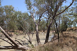
The Belyando River is a river in the east of the Australian state of Queensland .
geography
River course, agriculture, national parks
The river has its source on the eastern slopes of Mount Beaufort in the Drummond Range east of the city of Alpha , about 165 kilometers northeast of Blackall . From there it flows north along the east side of the Great Dividing Range , crosses under the Capricorn Highway at Pine Hill , the Alpha – Clermont road at Kingston and finally the Gregory Developmental Road at Belyando Crossing , where it forms the western border of Nairana National Park . A few kilometers further it flows into the Suttor River .
Its catchment area is 35,000 km². It is mainly used as pasture for cattle and, to a lesser extent, for agriculture. The land around the Belyando River is also home to the Narrien Range National Park and the Epping Forest National Park .
Tributaries with mouth heights
- Boorgoora Creek - 397 m
- Belyando River Western Branch - 390 m
- Eastern Creek - 387 m
- Spring Creek - 383 m
- Cattle Creek - 379 m
- Beaufort Creek - 371 m
- Myers Creek - 371 m
- Pinehill Creek - 352 m
- Breakaway Creek - 351 m
- Four Mile Creek - 334 meters
- Bottle Tree Creek -322 m
- Sandy Creek - 310 m
- Pebbly Creek -308 m
- Jampot Creek - 304 m
- Stockyard Creek - 293 m
- Schofield Creek - 277 m
- Native Companion Creek - 270 m
- Sandy Creek - 266 m
- Fiery Creek - 251 m
- Dunda Creek - 233 m
- Carmichael River - 216 m
- Tomahawk Creek -190 m
- Bully Creek - 188 m
- Mistake Creek - 188 m
- Six Mile Gully - 188 m
- Black Wattle Creek - 186 m
Flowing lakes
- Grays Lagoon - 387 m
- Bakoolama Waterhole - 339 m
- Ten Mile Waterhole - 327 meters
- Boadles Waterhole - 305 m
- Georges Waterhole - 270 m
- Broadna Waterhole - 231 meters
- Alinya Waterhole - 230 m
- Sandy Camp Waterhole - 229 m
- Brygana Waterhole - 217 m
- Dunjarrobina Waterhole - 212 m
- Yarmina Waterhole - 195 m
history
Aboriginal
The traditional administrators of the land that surrounds the Belyando River are the various indigenous Wakelbura peoples, including the various smaller Auanbura, Dorobura and Metherabura clans.
European exploration
The river was discovered and named in 1846 by explorer Thomas Livingstone Mitchell on his fourth and final expedition.
Floods
In 2011, the floods in Queensland caused extensive flooding on the Belyando River. Many houses and properties on its banks were cut off from the outside world for a long time and their residents had to be supplied with food.
See also
Individual evidence
- ↑ a b c d Map of Belyando River, QLD . Bonzle.com
- ^ A b Steve Parish: Australian Touring Atlas . Steve Parish Publishing, Archerfield QLD 2007. ISBN 978-1-74193-232-4 . P. 10
- ↑ Water resources - Overview - Queensland - Surface Water Management Area: Belyando / Suttor . In: Australian Natural Resources Atlas . Department of the Environment, Water, Heritage and the Arts . Archived from the original on June 22, 2009. Info: The archive link was automatically inserted and not yet checked. Please check the original and archive link according to the instructions and then remove this notice. Retrieved May 19, 2009.
- ↑ a b Belyando Basin . NQ Dry Tropics. Archived from the original on February 17, 2011. Info: The archive link was automatically inserted and has not yet been checked. Please check the original and archive link according to the instructions and then remove this notice. Retrieved September 26, 2011.
- ↑ unknown library: The native tribes of south-east Australia . London, Macmillan and Co., limited; New York, The Macmillan Company, 1904 ( archive.org [accessed May 17, 2020]).
- ↑ Moranbah . Isaac Regional Council. Retrieved May 19, 2009.
- ↑ Stranded residents may need more food drops . In: ABC News , Australian Broadcasting Corporation, January 6, 2011. Retrieved September 26, 2011.
