
Bemmel (Lingewaard)
 flag |
 coat of arms |
| province |
|
| local community |
|
| Residents | 16,600 (Jun. 30, 2017) |
| Coordinates | 51 ° 54 ' N , 5 ° 54' E |
| Important traffic route |
|
| prefix | 0481 |
| Postcodes | 5236, 6515, 6661-6663, 6681 |
 |
|
Bemmel is a part of the municipality of Lingewaard in the Dutch province of Gelderland . According to statistical data from June 30, 2017, the district had 16,600 inhabitants.
Until 2001, Bemmel was an independent municipality, which then merged with Huissen and Gendt. Bemmel lies between the larger cities of Arnhem and Nijmegen and is bordered by the rivers Rhine and Waal and the Linge . The next trunk road is the A15 .
The oldest building in Bemmel is a reformed church, which was built in the 12th century and was originally dedicated to St. Donatus . The newly built De Kinkelenburg is located in the center of the village . The town hall of Bemmel was located in the moated castle from the 13th century until the municipalities merged, now part of the municipal administration is housed there. In the years between 1990 and 2006 the new development areas Klein Rome , Klaverkamp and Essenpas were built .
As a secondary school there is a part of the Over Betuwe College in the village , there are also the primary schools De Donatushof , De Regenboog , De Mariaschool , De Pius X and De Borgwal .
There is an annual music festival and a pony market at the Buitenzorg Stud .
history
The XXX. British corps captured Bemmel in Operation Market Garden on September 24, 1944.
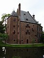
De Kinkelenburg
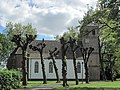
reformed Church

Pony market Bemmel 2004

Dike at Bemmel
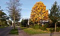
Road picture in autumn


Web links
Individual evidence
- ↑ a b Personen met een uitkering; soort uitkering, wijken en buurten 2017 Centraal Bureau voor de Statistiek , accessed on March 24, 2018 (Dutch)