Ben More Assynt
| Ben More Assynt | ||
|---|---|---|
|
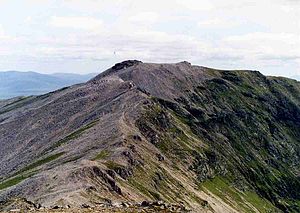
View to Ben More Assynt from the neighboring Conival |
||
| height | 998 m ASL | |
| location | Highlands , Scotland | |
| Notch height | 835 m | |
| Coordinates | 58 ° 8 '17 " N , 4 ° 51' 31" W | |
|
|
||
The Ben More Assynt is a 998-meter-high mountain in the Scottish Highlands . In Gaelic his name is Beinn Mhòr Asaint , which means Great Mountain of Assynt . It is the highest mountain in Assynt , a landscape in the Northwest Highlands and also in County Sutherland . The Ben More Assynt and the neighboring Conival are the only mountains in Assynt classified as Munro . Both mountains are part of a mountain range and its highest points running along the main watershed between the North Sea and the Scottish Sea from north to south through Sutherland. While the Conival lies in the course of the north-south chain, the Ben More Assynt is a little east of it. It has two peaks, in addition to the 998 m high main summit, the 960 m high south summit. Both are connected by a rocky and exposed ridge .
Geologically, the Ben More Assynt lies in the Moine Thrust zone , its summit area consists predominantly of Cambrian quartzite , which is superimposed here in the area of the Ben More Thrust along the ridge connecting the Conival and the Ben More Assynt gneiss from the Lewisian . Only the south summit and the connecting ridge to the main summit are made entirely of gneiss.
Due to the location of Ben More Assynt east of the mountain range and its connecting ridge to the Conival, both mountains are usually climbed together. The starting point is the small town of Inchnadamph on the A 837 at the south end of Loch Assynt . From there the path leads in the valley of the Traligill River to the east and gradually ascending on the northern side of the valley to a Bealach between the Conival and the 775 m high Beinn an Fhurain to the north . The path leads south to the summit of the Conival and then to the east over the narrow, sometimes easy climbing ridge to the neighboring main summit of Ben More Assynt. There are also opportunities for ascent from the east and south, but due to the lonely location, these require longer approaches and are usually not manageable in one day.
Individual evidence
- ^ Scottish Mountaineering Club Munro List , accessed April 10, 2018
- ↑ Kathryn Goodenough, Maarten Krabbendam: Conival and Ben More Assynt, North-west Highlands - an excursion , in: EARTHWISE: The digital publication channel for the British Geological Survey , accessed September 8, 2017
Web links
- The Ben More Assynt on walkhighlands.co.uk (English)
- The Ben More Assynt on munromagic.com (English)


